“Nothing to return to”: Israel’s demolitions and settlements in Gaza, the West Bank, and Lebanon

5 min read

CIR

CIR 's photo

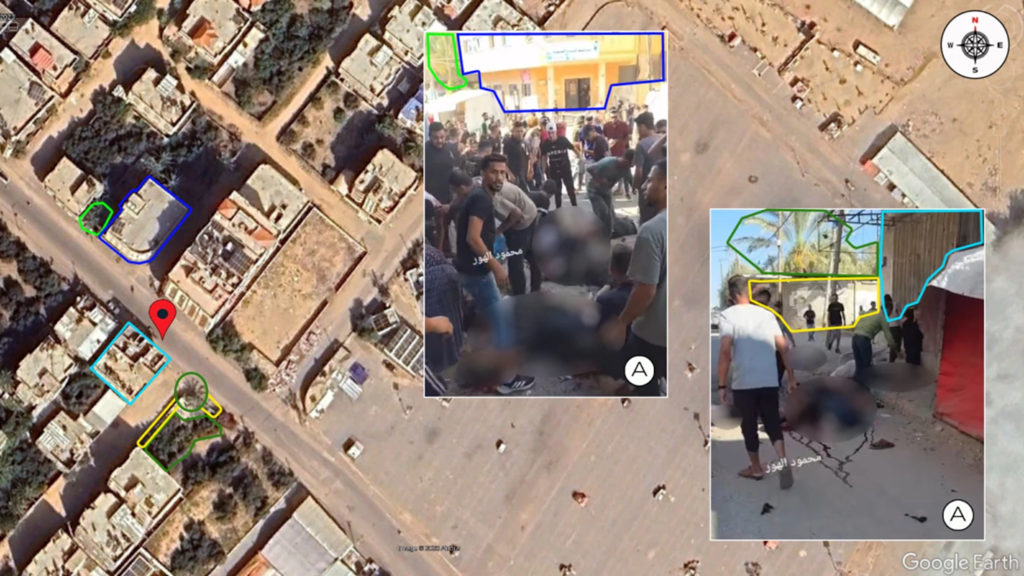
CIR’s geolocation of IPIN3874, showing at least nine casualties and a likely munition crater in Nuseirat camp, Gaza, at coordinates: 31.4471, 34.3859. Sources: Google Earth Pro, Airbus (10/2023); A: IP17207.

Share Report

CIR verified 81 incidents across Gaza, the West Bank, and Lebanon between 1 July and 28 September 2026, which indicate that Israel’s government and military appear to be pursuing a systematic expansion of its territory.

CIR has produced a summary of its findings relating to possible Israeli attempts to expand its territory in Gaza, the West Bank, and Lebanon, from 1 July to 28 September 2026.  

The evidence analysed within this summary, which includes verified incidents and statements, falls under three new categories: 

  • Israeli expansion: Incidents showing new Israeli constructions outside of Israeli territory, or the controlled demolition of non-military infrastructure. 
  • Population harm: Incidents that put local populations in danger or damage objects indispensable to the survival of the civilian population (such as residential homes, farmland, water infrastructure, medical facilities, and power supplies). 
  • Settler activity: Violent incidents involving likely Israeli settlers. 

Across these categories, CIR has verified 81 incidents from 177 images and videos showing possible International Humanitarian Law violations across Gaza, the West Bank, and Lebanon during the past quarter.  

Gaza

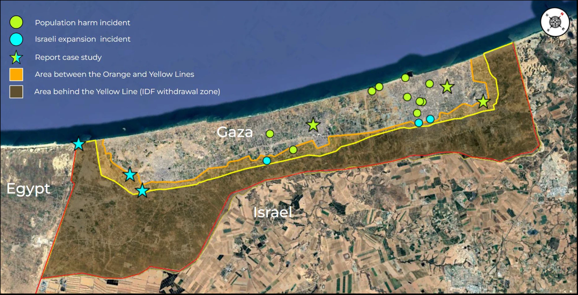
CIR’s map of incidents in Gaza during the past quarter. Source: Google Earth Pro, Airbus (25/02/2026).

Despite a ceasefire agreement signed between Israel and Hamas on 10 October 2025, CIR has continued to verify Israeli military activity in Gaza throughout the past quarter. Within the 18 recorded incidents from this monitoring period, a total of 35 casualties were identified, 32 of which were adults and three were minors. These figures reflect only what can be verified through open-source investigations and do not account for every casualty. Gaza’s Health Ministry, in figures shared by Al Jazeera, recorded 1,066 civilians and combatants killed as of 4 July and 1,422 as of 29 September, a rise of 356. CIR also verified seven airstrikes on civilians and police checkpoints.

Content shared on 17 July 2026 shows at least nine casualties 80 metres southeast of the Ahmad Yassin Mosque in Nuseirat refugee camp. Witnesses, whose statements were collected by Al Jazeera, said a drone targeted Palestinian mourners gathered outside the mosque as they waited to begin a funeral procession. Al Jazeera also reported that the IDF’s response to the incident was that it “struck a ‘terrorist’ cell in central Gaza” and was looking into “claims that several uninvolved individuals were harmed”. CIR did not identify the original IDF statement that made these claims. 

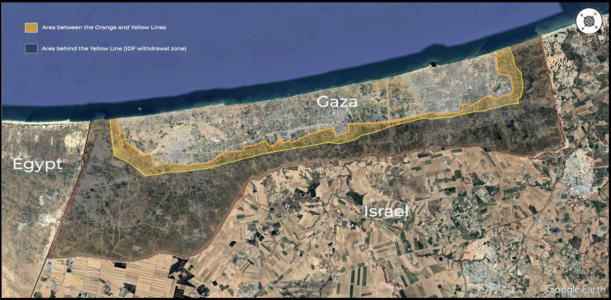
CIR’s map showing the Orange Line and Yellow Line in Gaza. Sources: Google Earth Pro, Airbus (23/12/2024); IDF Website Map. 

The Yellow Line marks the edge of the area of Gaza that the IDF has designated a “combat area”. The Orange Line, reportedly set by the IDF in early 2026 and not physically marked on the ground, denotes the western edge of the area between the two lines. According to Reuters, the IDF described the area between the Orange Line and Yellow Line as “a restricted zone to enable aid delivery”. However, UN agencies have noted that an estimated 14,133 households and 10 UNRWA installations, including emergency shelters, are located within the restricted zone. Media reports have therefore described the Orange Line as restricting the movement of UN aid teams, delaying emergency deliveries, and preventing civilians from accessing their homes. 

Findings from the UN Food and Agriculture Organisation show that the Orange Line boundary has further restricted Gazans’ access to farms; only 3% of Gaza’s cropland is currently both accessible and undamaged, as well as only 16.6% of its greenhouses. 

National Security Minister Itamar Ben-Gvir stated during a pro-settlement protest, “If someone had said three years ago we would control 70% of the Gaza Strip, no one would have believed it. So today I say: there will be Jewish settlements throughout Gaza”. 

In addition to the 18 fully verified entries in Gaza, CIR has identified a further 30 incidents involving 65 casualties across Gaza during the past quarterly period. These 30 incidents have not been included in this report, as they are yet to undergo CIR’s rigorous review process.  

West Bank

Of the 34 verified incidents, 14 fall within the Israeli expansion category and show a likely intention by Israel to expand its control within the West Bank. This aligns with reporting from UN OCHA, which announced that “more than 1,600 Palestinians have been displaced by demolitions across the West Bank” in 2026.  

Notably, at least 21 commercial and agricultural buildings were demolished in the eastern outskirts of Jenin in the northern West Bank. The ongoing demolition of infrastructure in the West Bank demonstrates Israel’s likely intent to disrupt economic activity and impede the return of Palestinians to the affected areas, potentially indicating an intent to facilitate their displacement.  

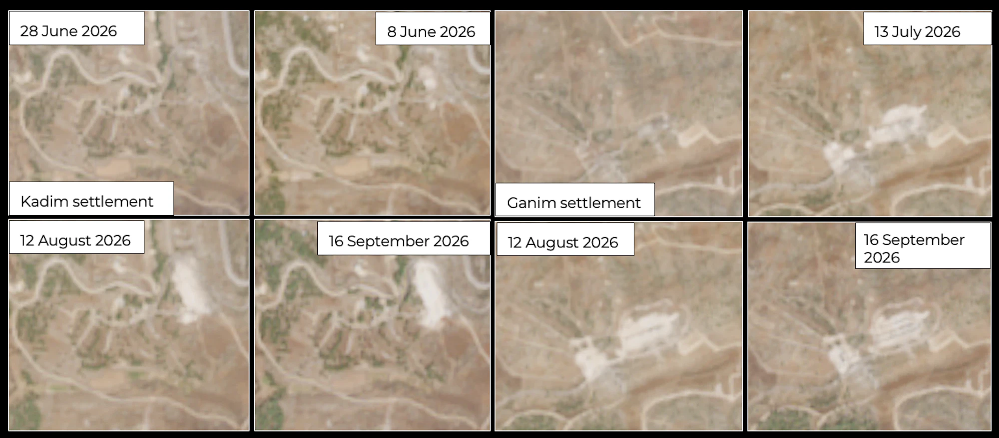
Israeli Finance Minister Bezalel Smotrich wrote, “This morning [12 August 2026], an operation began to demolish 26 illegal Arab structures in the Ganim and Kadim area in northern Samaria – ahead of the renewal of settlement in the area.” CIR analysed satellite imagery of the area and confirmed that demolitions occurred within two kilometres of the Ganim and Kadim settlements, which were re-established on 13 and 20 August 2026, respectively.  

A comparison of satellite imagery showing development at the Ganim settlement (left) and the Kadim settlement (right). Source: Sentinel-2 Level-1C imagery. 

During the opening ceremony of the Ganim settlement, Defence Minister Israel Katz stated, “This is the land of Israel and we are staying here forever”. 

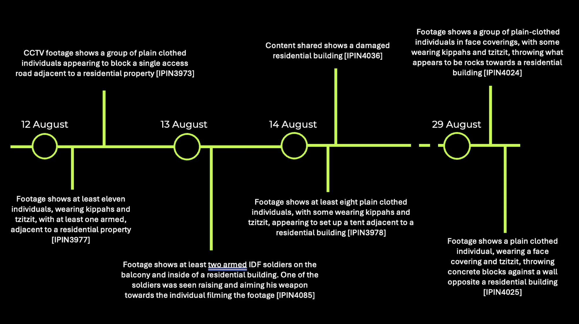
Timeline of incidents that occurred in Qusra throughout August 2026. 

In Qusra, southeast of Nablus, footage shared on 30 August and 1 September 2026 shows a group of plain-clothed individuals in face coverings, some of whom are wearing kippahs and tzitzit, throwing what appear to be rocks towards a residential building. The IDF claimed that “upon their arrival, the security forces identified dozens of rioters who had barricaded themselves inside a Palestinian home while Palestinian residents were inside”. At the time of writing, CIR could not verify any casualties related to the incident and did not find any further information regarding the IDF’s investigation of the incident.  

Lebanon

CIR verified a total of 29 incidents in Lebanon between 1 July 2026 and 28 September 2026. Of these, 11 show a likely intention by Israel to expand its control within Lebanon. CIR assesses that these patterns indicate Israel’s intention to make areas within the security zone uninhabitable on a long-term basis.  

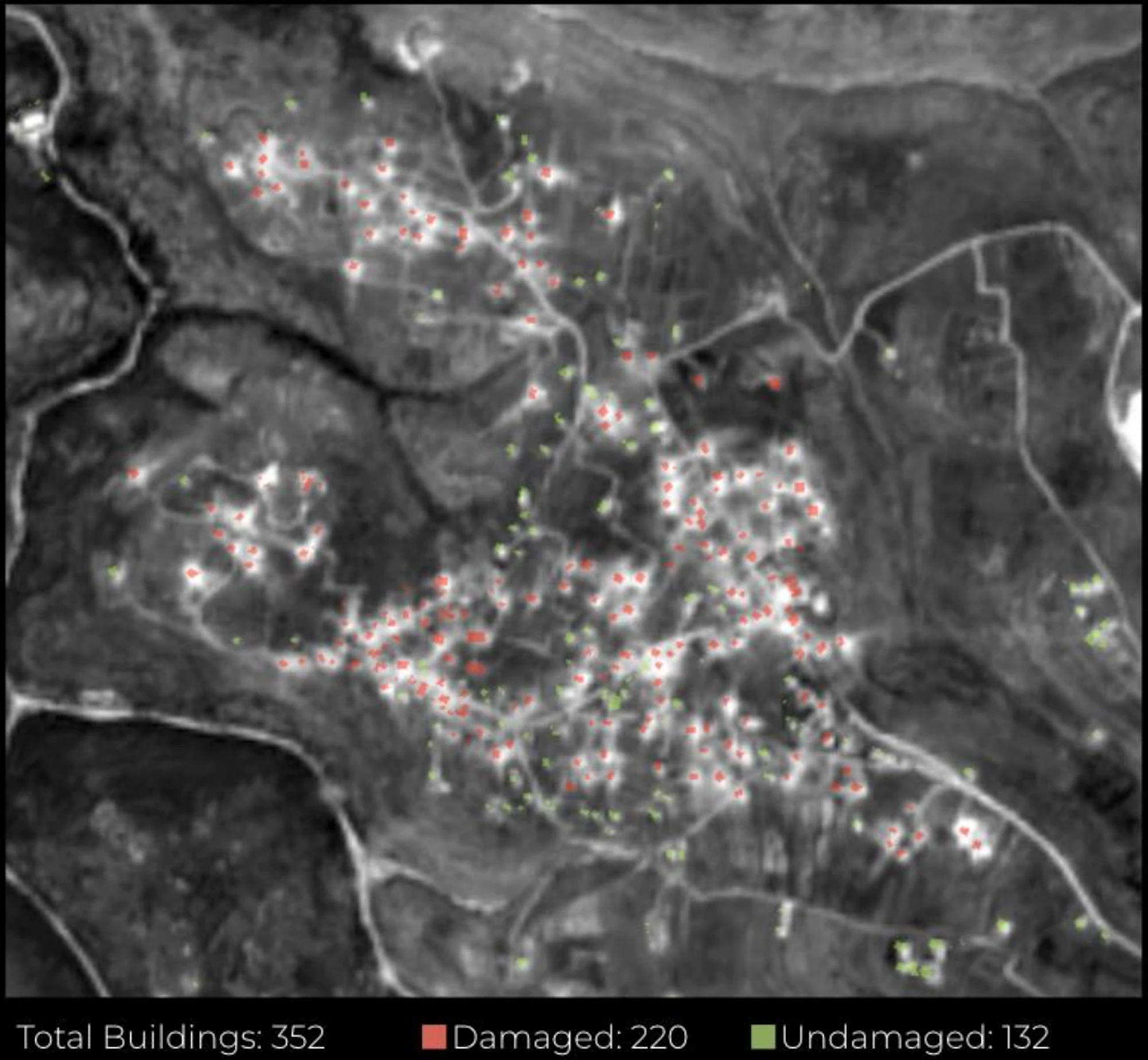
CIR’s building damage assessment of Bani Haiyyan showed damage to 62.5% of buildings as of 13 September 2026. Source: Sentinel-2 Level-2A imagery. 

In the town of Bani Haiyyan, which lies adjacent to the Israeli Security Zone boundary, CIR found that 220 of the town’s 352 buildings show changes consistent with destruction or severe damage between 12 August and 10 September 2026. This equates to 62.5% of the buildings within the town. By destroying homes and potentially the access roads, Israeli forces leave civilians with nothing to return to. Speaking at a conference, Katz stated, “Twenty-four Lebanese villages that were hundreds of years old…we destroyed all of the buildings…We’re talking about 15,000 to 20,000 homes.”

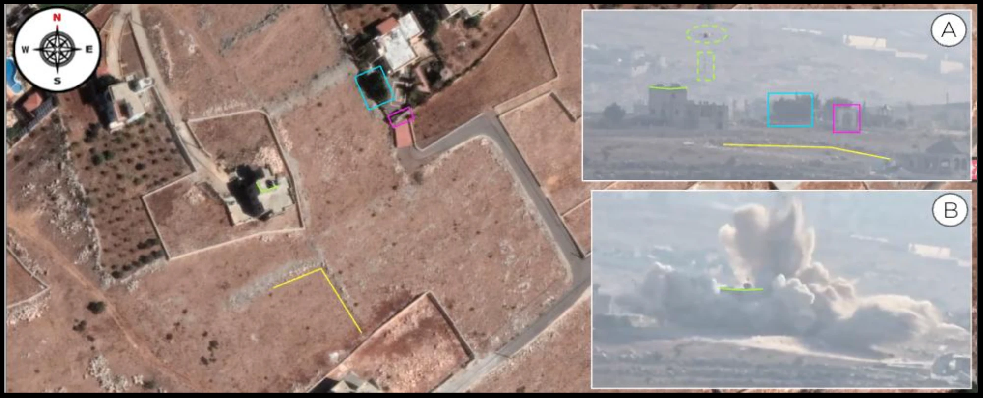
CIR’s geolocation showing a drone lowering containers onto the roof of a building which then explodes in Bani Haiyyan, at coordinates: 33.2511, 35.4864. Sources: Google Earth Pro, Maxar Technologies, 28/09/2022; A: IP18165; B: IP18166. 

CIR has verified three pieces of footage showing quadcopter drones carrying and lowering white containers onto buildings that were later demolished. CIR has been unable to identify what the white containers are or the substance they contain, but believes them to be some type of ignitor, flammable, or accelerant element linked to the demolitions.  

According to the South Lebanon Water Establishment, as of July 2026, 175 water reservoirs, 16 pumping stations, 124 wells, 9 springs, and 104 chlorination systems have been damaged since 2024.  

CIR will continue to monitor for incident and statement trends relating to Israeli attempts to expand its territory during the next quarter. Read the full report for more details on CIR’s findings and methodology.

Share Report