Key Event Details
Case Study locations: five in-depth case studies in the following locations in Chin state (ချင်းပြည်နယ်):
Khuafo (ခွါဖိုး) village, Thantlang township (ထန်တလန်မြို့နယ်), [22.751320, 93.425133]; two case studies in this location.
Tlanglo (တလန်လို) village, Thantlang township (ထန်တလန်မြို့နယ်), [23.008120, 93.336327].
Malsawm (မာလ်ဆောမ်) village, Hakha township (ဟားခါးမြို့နယ်), [22.516581, 93.786957].
Ramthlo (ရမ်ထလို) village, Falam township (ဖလမ်းမြို့နယ်), [22.825451, 93.560120].
Date/Time of Incident:
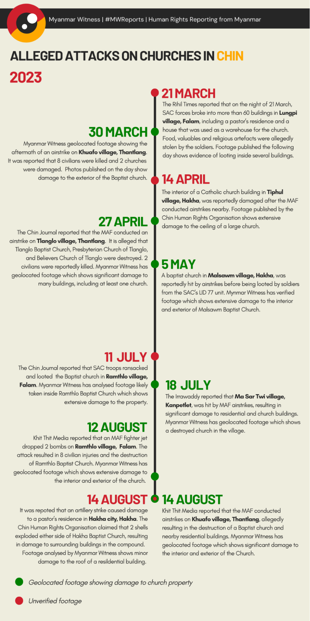
10 events between 21 March 2023 and 14 August 2023.
5 case studies between 30 March 2023 and 14 August 2023.
Alleged Perpetrator(s) and/or Involvement:
Myanmar Air Force (MAF)
Myanmar Military
Chinland Defence Force (CDF)
Chin National Army (CNA)
Chin National Defence Force (CNDF)
Summary of Investigation:
Churches across Chin state have been affected by the ongoing violence. Airstrikes, artillery attacks, raids and arson have allegedly resulted in extensive damage to places of worship — spaces which are protected during conflict under international law.
Myanmar Witness identified and analysed 10 incidents impacting churches in Chin between March and August 2023.
7 of the 10 incidents involved allegations of airstrikes. Myanmar Witness geolocated User Generated Content (UGC) relating to six of these events.
All 10 incidents occurred in townships placed under martial law on 2 February 2023.
Of the 10 incidents, Myanmar Witness investigated 5 case studies and geolocated UGC, showing damage to church buildings in Thantlang, Falam and Hakha townships. The case studies were selected due to the intensity of the event and the presence of verifiable open-source content.
Myanmar Witness also collected data from Armed Conflict Location & Event Data (ACLED) to investigate broader trends within an extended timeframe. 28 reports of damage to churches in Chin state were logged between 1 February 2021 to 8 September 2023.
The ACLED data indicates that in 2023, there was a shift in tactics. Between 2021 and 2022, churches were reportedly damaged by frequent arson and artillery attacks. In 2023, airstrikes were allegedly involved in most cases.
Though resistance forces were allegedly involved in several incidents, they were never reported as the perpetrators by online media.
Analysis of ACLED data alongside the case studies suggests that the use of airstrikes has increased since 2022, supporting claims previously made by Myanmar Witness. This is reflected in the nature of the damage to churches in Chin state. One of the case studies could indicate that the church was intentionally targeted, however the motivation for the attack cannot be verified.
Executive summary
Since the February 2021 coup, religious buildings throughout Myanmar have been widely affected by the conflict. This investigation has examined the impact on churches in Chin, the only state with a majority Christian population.
Myanmar Witness investigated 10 claims of physical damage to churches in Chin state in 2023. Airstrikes were reported in seven of the analysed incidents. The Myanmar Air Force (MAF) maintains overwhelming air superiority across Myanmar, supporting the claim that the Myanmar military was responsible for the alleged airstrikes. Though resistance forces are known to utilise drones to attack SAC positions, these are not long-endurance or high-payload platforms. All 10 events investigated by Myanmar Witness reportedly took place in townships which were placed under martial law on 2 February 2023.
From these 10 incidents, Myanmar Witness investigated five case studies and geolocated User Generated Content (UGC) of church buildings in Thantlang, Falam and Hakha townships. Through an analysis of UGC showing physical damage, these examples indicate how conflict across Chin is impacting churches – sites that come with special protections during conflict under international law.
Myanmar Witness also gathered data from Armed Conflict Location & Event Data (ACLED) covering February 2021 to September 2023. 28 reports of damage to church property were reported in this timeframe in Chin state. Myanmar Witness categorised this data by incident type, identifying airstrikes, artillery, arson and looting as the principal alleged causes of physical damage. This analysis reveals a shift in incident type over time: airstrikes became the primary cause of damage in 2023 and there were fewer reports of arson and artillery strikes compared to data for 2021 and 2022. This trend may reflect a loss of ground control by the State Administrative Council (SAC) in Chin state.
The conflict has profoundly impacted the cultural and religious landscape of Chin state. The examples analysed in this report reflect the degradation of Myanmar’s built environment, including sites with special protections under international law during armed conflict. It is clear that the day-to-day activities of ordinary citizens continue to be disrupted as a result of the conflict.
Methodology
Myanmar Witness follows a methodology of digital preservation and rigorous, replicable analysis. Digital evidence is collected and archived in a secure database and preserved with hashing to confirm authenticity and prevent tampering.
To read the Methodology and Limitations, download the PDF.
Background and Context
On 1 February 2021, the Myanmar military staged a coup that overthrew the democratically elected National League for Democracy (NLD) party led by Aung San Suu Kyi, and replaced it with members of the military through the State Administrative Council (SAC). In response to this, thousands of people took to the streets in protest and a civil disobedience movement formed across Myanmar. Since then, the conflict in Myanmar has evolved and spread; what started as the violent repression of largely peaceful pro-democracy protests in major urban areas has developed into a country-wide civil war. There appears to be a concerted effort to violently suppress opposition to the military regime through airstrikes, fire and ground raids.
Myanmar Witness has actively monitored events following the February 2021 coup and investigates cases where alleged human rights interferences have occurred. Additionally, Myanmar Witness has monitored the impact of specific tactics on Christian churches and other religious buildings. These tactics, which include unguided airstrikes, fires, raids, arrests and destruction of property, all harm local communities. Myanmar Witness has documented the impact of similar tactics on schools, medical facilities, public administration and concert events.
Chin state, bordering India and Bangladesh, is a mountainous region located in western Myanmar. With a population of around 530,000 people, Chin accounts for just over 1% of the national population, making it the least densely populated township in the country. Christians comprise 85% of Chin’s population, making it the only state in Myanmar with a majority Christian population. For comparison, Christians account for only 6% of the total population of Myanmar.
Since the February 2021 coup, Myanmar Witness has regularly identified and verified incidents where churches have been impacted as part of the conflict. There continue to be airstrikes, raids and fires on such sites throughout Myanmar. Many international agreements and laws affirm the shared understanding that there is a need and obligation to protect religious buildings.
Though this report focuses on alleged attacks in 2023, the impact of earlier conflict is still felt by communities across Chin state. Myanmar Witness has reported on the devastation of towns such as Thantlang, where the Myanmar military’s alleged use of scorched earth tactics destroyed civilian houses, schools, civic buildings, and Christian churches.
Under Customary International Humanitarian Law, as outlined by Rule 38 A of the International Committee of the Red Cross’ (ICRC) International Humanitarian Law (IHL) Databases, “[s]pecial care must be taken in military operations to avoid damage to buildings dedicated to religion, art, science, education or charitable purposes and historic monuments unless they are military objectives.” While this investigation does not attempt to determine whether the damage to churches was the result of intentional, direct attacks, open-source investigation reveals that Christian churches have been affected by the conflict. From historical edifices to converted residential properties, damage to places of worship undermines religious liberty.
Martial law in Myanmar
On 2 February 2023, the SAC’s Martial Law Order 1/2023 transferred administrative and judicial authority to military commanders in 37 townships. Seven townships in Chin state were affected by the decree: Falam, Hakha, Kanpetlet, Matupi, Tedim, Thantlang and Tonzang. Mindat township, in southern Chin state, was already under martial law, pursuant to Martial Law Order 4/2021 which was issued on 13 May 2021.
Myanmar Witness analysed the correlation between airstrikes and martial law across Myanmar, finding that the townships affected by the 2 February order appeared to have been disproportionately affected by airstrikes in the latter half of 2022 (see Figure 1 on the following page). These attacks may indicate that martial law was imposed in active conflict zones and areas of symbolic resistance where the SAC attempted to eliminate strategic targets.
An additional policy was identified which may have more directly curtailed the religious freedoms of Christians across Chin state. It was reported that on 13 February 2023, SAC officials in the state issued an order requiring churchgoers to give a week’s notice prior to attending any religious service. The order applied to the eight townships in Chin which were under martial law.
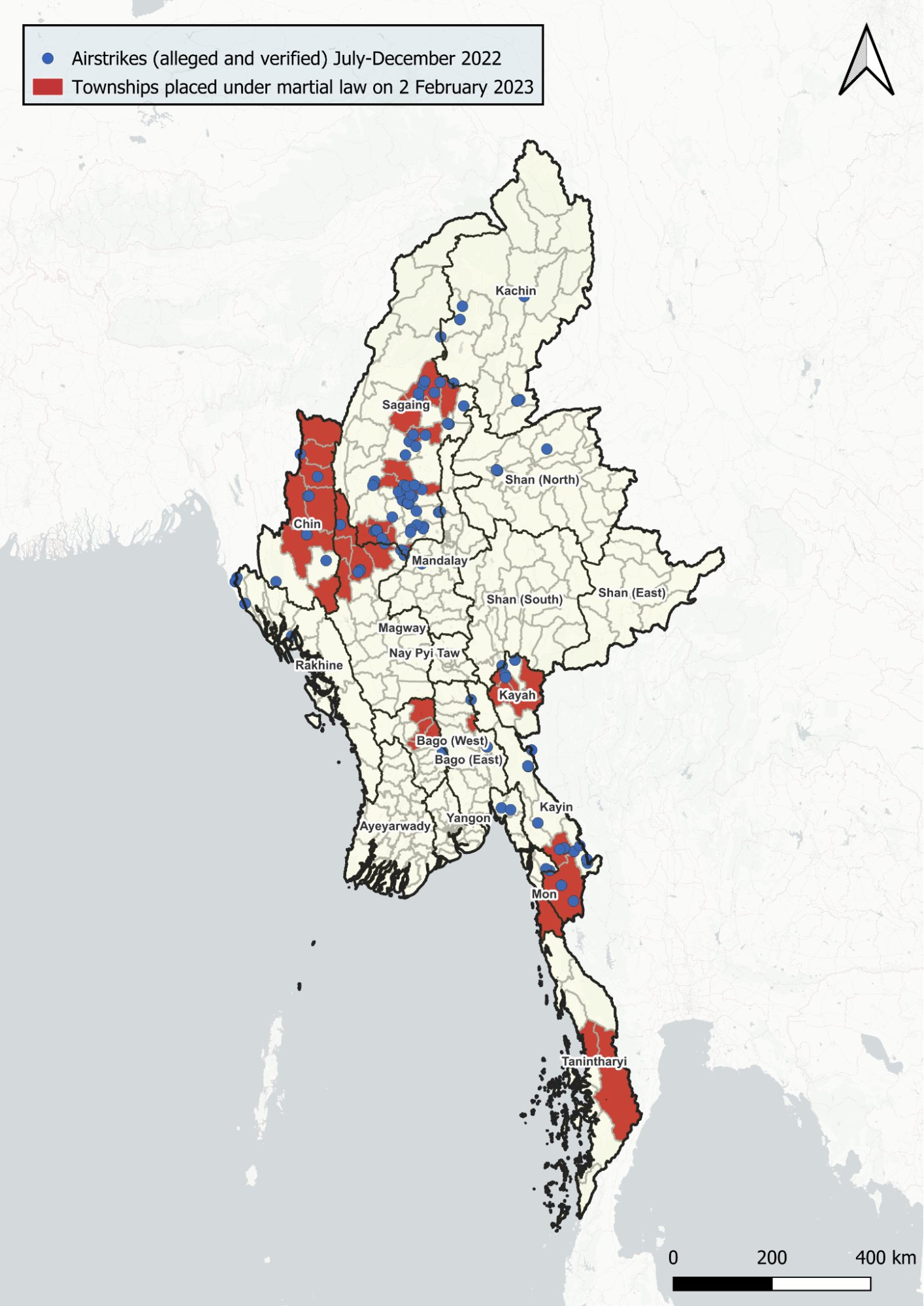
Figure 1: Map showing the locations of airstrikes recorded by Myanmar Witness from July-December 2022. Some incidents have been verified while others are claims. Townships which were placed under martial law on 2 February 2023 are highlighted in red. Further details and methodology can be found in Myanmar Witness’ Eyes
on the skies report. Map created by Myanmar Witness using QGIS.
Incident timeline
Incident map
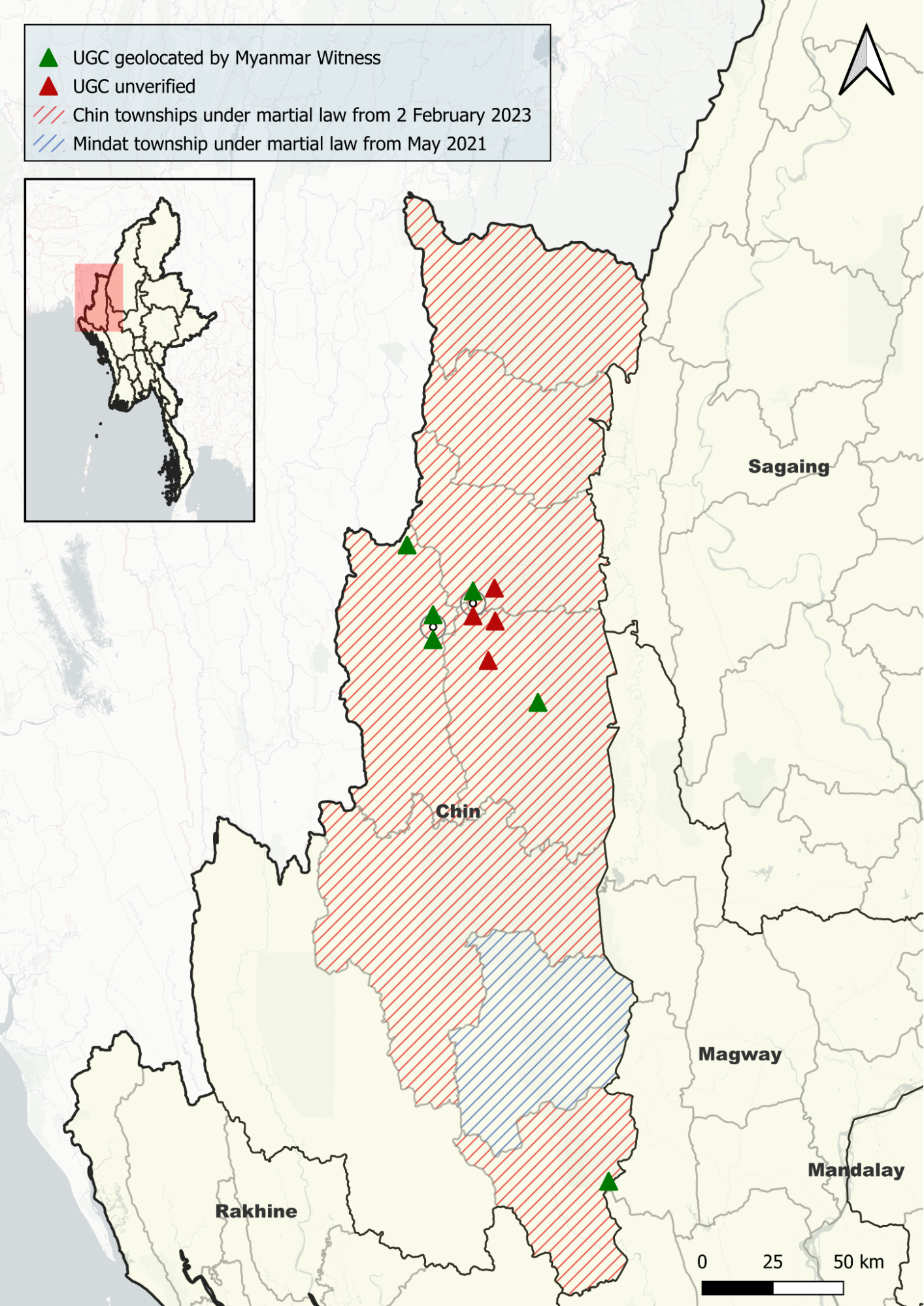
Figure 2: Map showing the locations of alleged incidents analysed by Myanmar Witness. Events with geolocated UGC are shown in green, while unverified events are in red. Townships which were under martial law from 2 February are highlighted in red. Mindat township, under martial law since May 2021, is highlighted in blue. Map created by Myanmar Witness using QGIS.
ACLED trends 2021-2023
Myanmar Witness collated 28 ACLED reports which allegedly involved damage to churches. There were eight reported incidents in 2023, six in 2022 and 14 in 2021. While useful for understanding trends, this data has not been verified and comprises textual reports only.
Trends in the ACLED data point towards a change in conflict dynamics in 2023. There were six reports of airstrikes in 2023, which allegedly resulted in damage to church buildings. This is a significant increase from 2022 when only one airstrike was reported. Similarly, in 2021, ACLED did not report a single incident where an airstrike allegedly caused damage to a church.
The increased frequency of alleged airstrikes in 2023 corresponded with a drop in reports of looting, arson and artillery strikes. ACLED recorded eight claims of arson in 2021, dropping to three reports in 2022 and only one in 2023. Artillery strikes accounted for five alleged incidents in 2021, while only one report mentioned artillery in 2022 and 2023. There were no reports of looting recorded by ACLED in 2023, with one allegation of looting having been recorded in 2021 and one further claim in 2022.
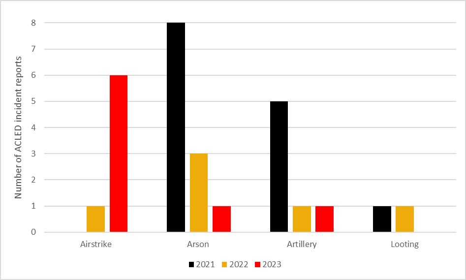
Figure 3: Graph showing number of ACLED reports (y-axis), categorised by allegation type and year (x-axis). Graph created by Myanmar Witness using Microsoft Excel.
ACLED analysis suggests that incidents involving infantry presence near churches declined in 2023 and were replaced by the increased use of air power. An apparent change in tactics may reflect the Myanmar military’s diminished ground control in Chin state. Despite changes in conflict dynamics, the data confirms that since August 2021, churches have been consistently impacted by the conflict.
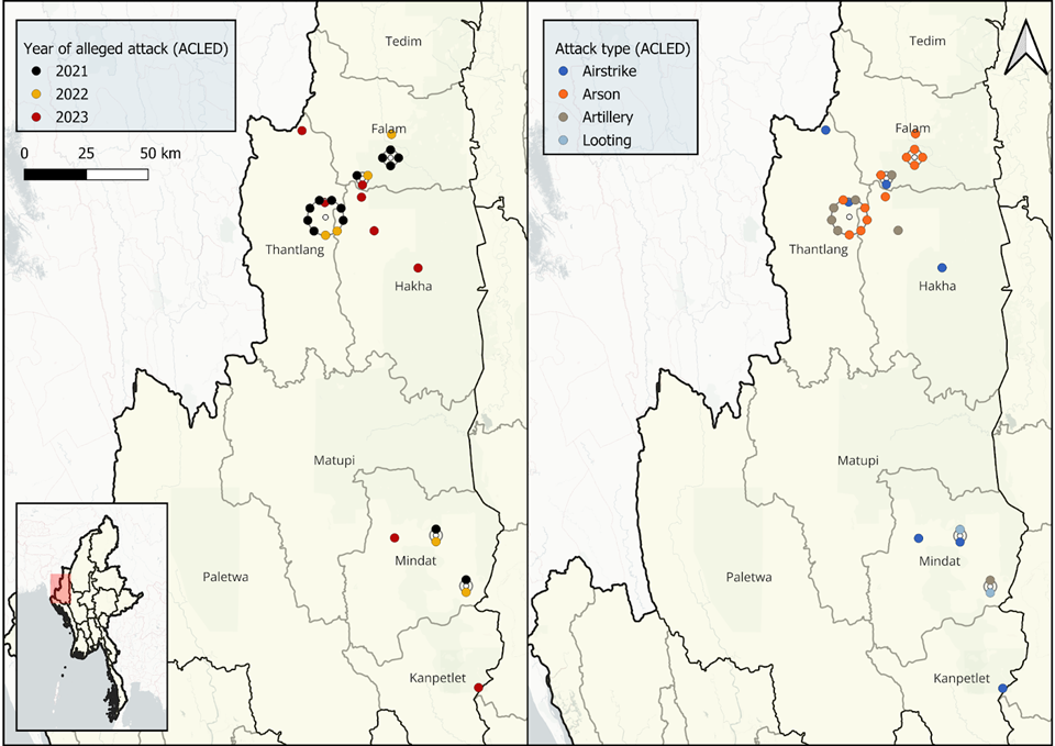
Figure 4: Maps of alleged attacks on churches logged by ACLED. The incidents are from August 2021 to August 2023. The incidents are colour coded according to the year of the alleged attack (left) and the attack type (right). Maps created by Myanmar Witness using QGIS.
The devastation of Thantlang, previously reported on by Myanmar Witness, is reflected in the ACLED data from 2021 and 2022. Allegations centred around Thantlang accounted for nine of the 20 ACLED reports logged in this time frame. In 2021 alone, ACLED logged seven incidents in this town, of which five were allegations of arson. Conversely, in 2023, there were no further reports of damage to churches in Thantlang, which, by then, was almost entirely burned down and abandoned.
Case studies
After identifying 10 incidents within the analysis timeframe, five case studies were selected for deeper investigation due to the intensity of the event and the presence of verifiable open-source content. These case studies are outlined below. Each case involves physical damage to church buildings, allegedly caused by the Myanmar military. In each case study, airstrikes were a reported cause of structural damage.
All five cases are partially verified through geolocation. Figure 5 shows the locations of the five events.
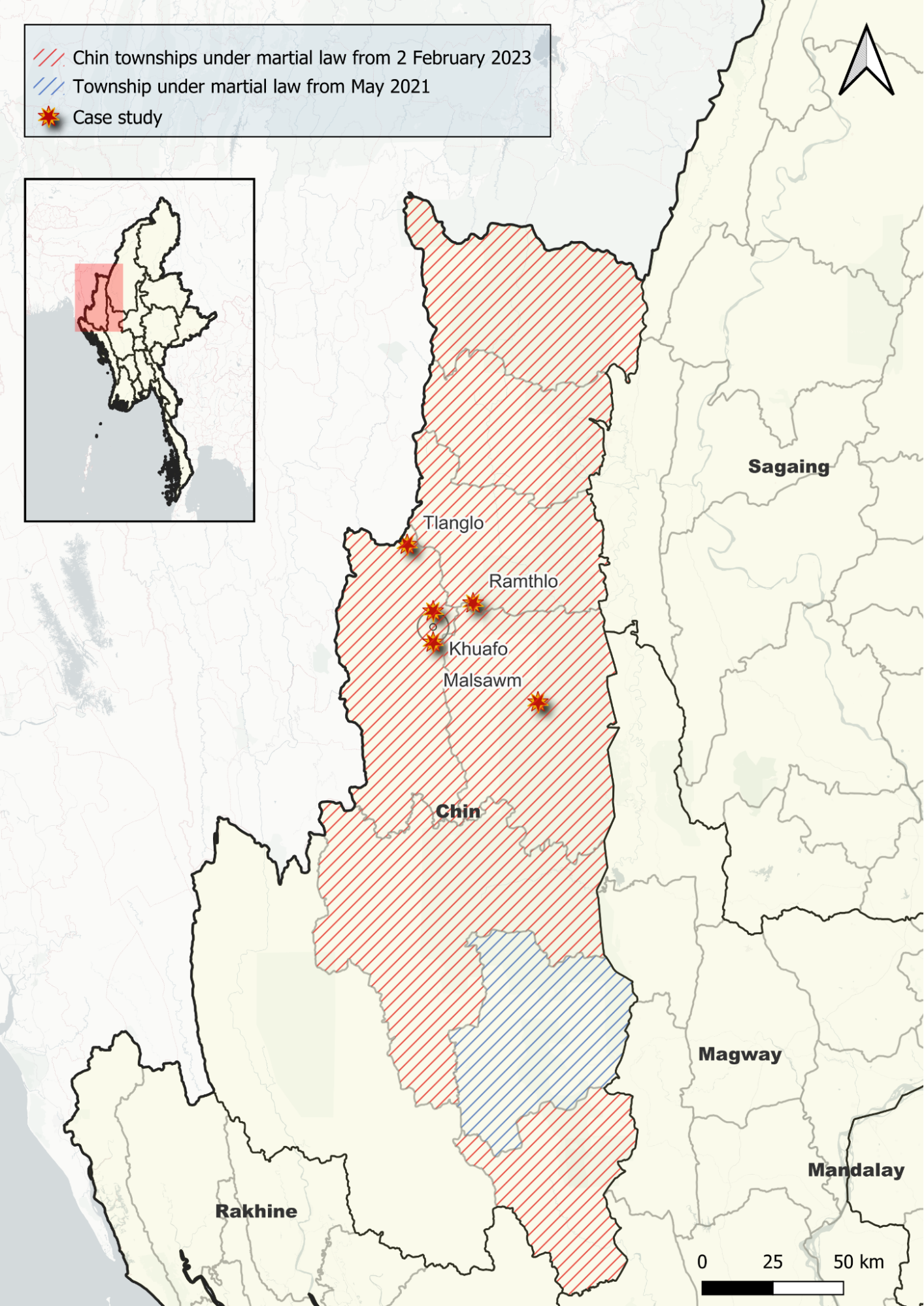
Figure 5: Map showing the locations of case studies analysed in this report. Townships which were under martial law from 2 February are highlighted in red. Map created by Myanmar Witness using QGIS.
1. Khuafo Baptist Church
Thantlang, Chin, 30 March 2023
On 30 March 2023, it was reported that eight civilians died and 13 were critically injured following an MAF airstrike on Khuafo (ခွါဖိုး) village [22.751320, 93.425133]. The attack allegedly occurred at 1015 local time when two MAF fighter jets and a Mi35 attack helicopter dropped bombs on the village. In a press release, the National Unity Government (NUG) reported that two churches and 13 houses were destroyed. Myanmar Witness has been unable to verify this claim.
UGC released (warning: graphic link) on the day of the alleged attack and geolocated by Myanmar Witness shows damage to several buildings in the village, including Khuafo Baptist Church. Due to cloud coverage obscuring satellite imagery, it was not possible to verify the date of the alleged airstrike through chronolocation. Additional images have been widely shared (warning: graphic link) online apparently depicting burial ceremonies for the deceased villagers, whom various outlets have also named. Myanmar Witness has not verified this footage.
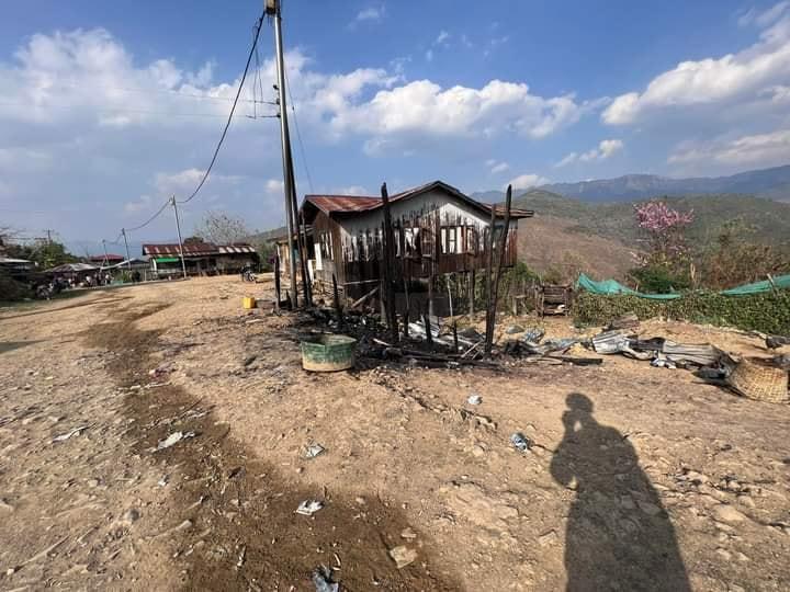
Figure 6: Houses were reportedly destroyed in Khuafo following MAF airstrikes. UGC geolocated by Myanmar Witness shows structural and fire damage to several residential buildings. One building [22.751467, 93.425619] was seemingly reduced to ashes (source: Khonumthung Burmese, warning: graphic link).
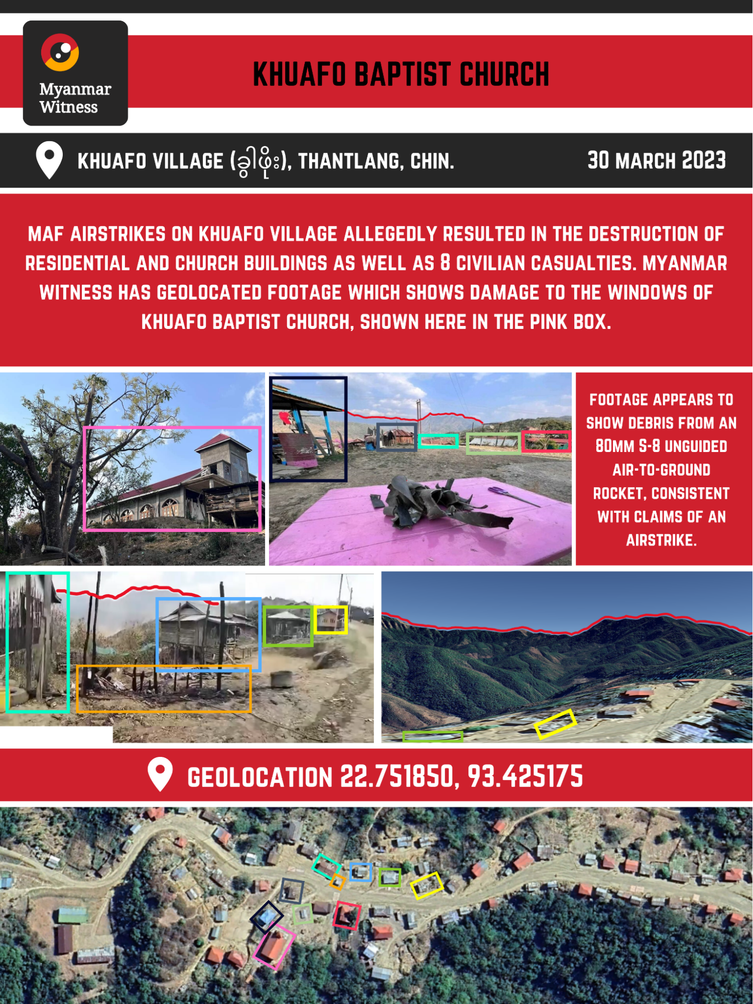
Figure 7: Infographic created by Myanmar Witness including geolocated UGC which purports to show the aftermath of an airstrike in Khuafo [22.751744, 93.425397] (sources: Khonumthung Burmese, warning: graphic link; Vafim Thuro; The Chin Post).
Analysing the incident
Local media shared (warning: graphic link) extensive footage reportedly showing the aftermath of MAF airstrikes in Khuafo. Images shared by Khonumthung Burmese (warning: graphic link) on the day of the alleged airstrike, appear to show minor damage to the exterior of Khuafo Baptist Church (see Figure 8 below). Myanmar Witness has geolocated UGC, which shows smashed windows on the south-facing side of the building. Investigators were unable to verify that this damage was sustained as a result of the alleged airstrike.
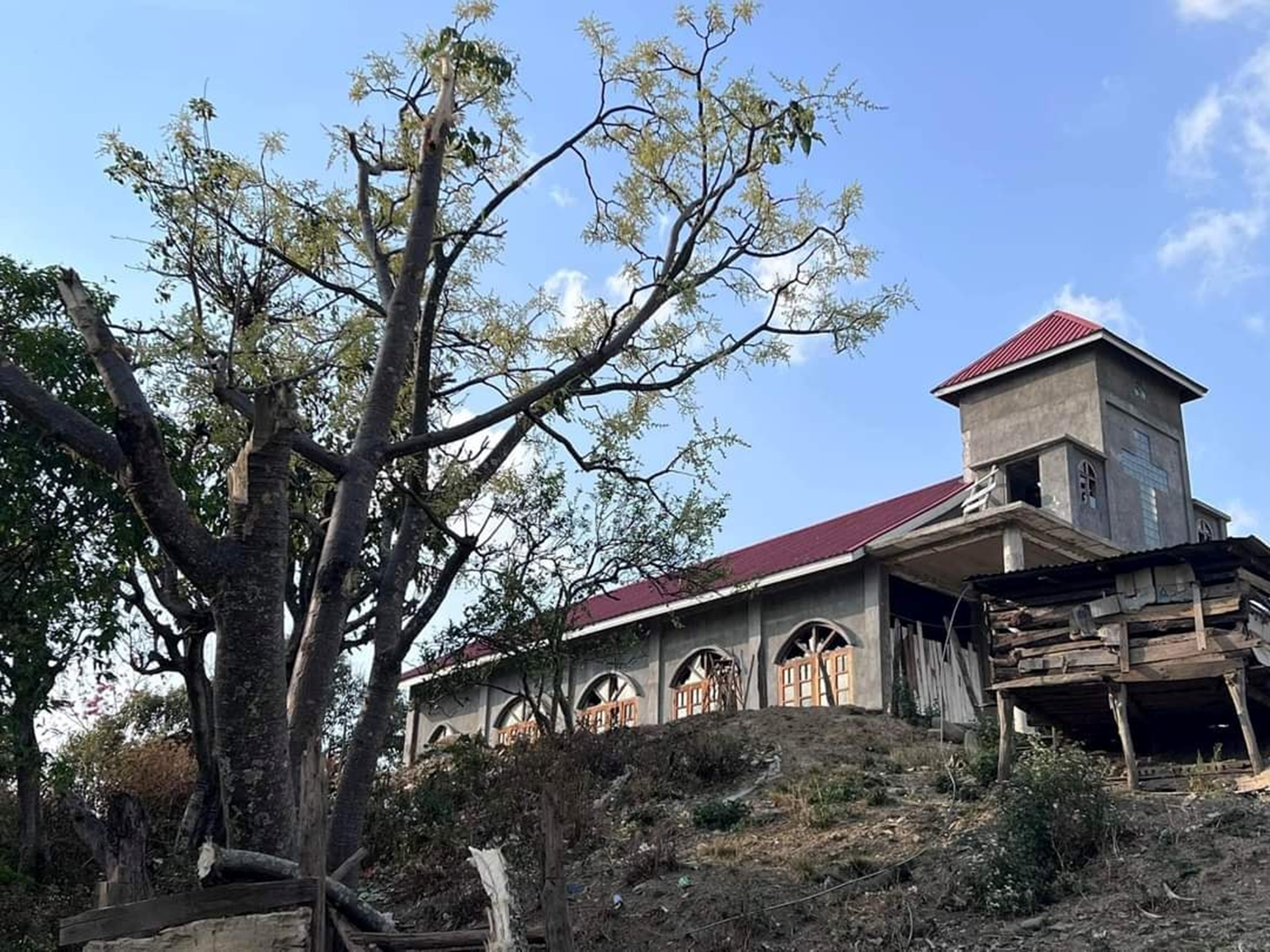
Figure 8: It is alleged that Khuafo Baptist Church was damaged following airstrikes on 30 March. UGC shared on the day appears to show smashed windows [22.751632, 93.425222] (source: Khonumthung Burmese, warning: graphic link).
Myanmar Witness has also analysed images showing considerable damage to residential buildings in the village. UGC shows structural damage to buildings near the Khuafo Baptist Church. One house appears to have a large hole in its exterior wall and significant damage to the interior (see Figure 9 on the following page). Myanmar Witness was unable to verify that this damage was sustained due to an airstrike. However, the extent of structural damage suggests that a weapon of considerable power was responsible.
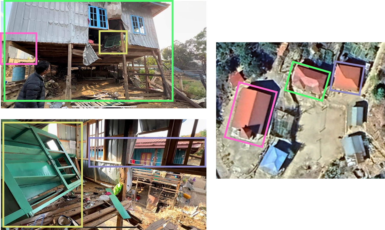
Figure 9: Myanmar Witness has geolocated footage showing significant damage to the residential buildings which neighbour Khuafo Baptist Church, shown here in the pink box [22.752130, 93.425063] (source: Ayeyarwaddy Times, warning: graphic link).
Myanmar Witness has analysed UGC, allegedly showing debris recovered after the reported airstrike. The crumpled metalwork is consistent with damage sustained by a long rocket upon impact. Munitions analysis identified parts of the fin section from an S-8 80mm unguided rocket (see Figure 10 below). However, Myanmar Witness was unable to verify that the debris originated from the same weapon. The footage was geolocated and shows wreckage arranged on a pink tray in front of Khuafo Baptist Church (see Figure 11 on the following page). Since S-8 rockets are exclusively air-launched, the apparent presence of debris is consistent with the allegation of an airstrike. Given its proximity to a known place of worship, this UGC sustains the allegation that the conflict has impacted churches.
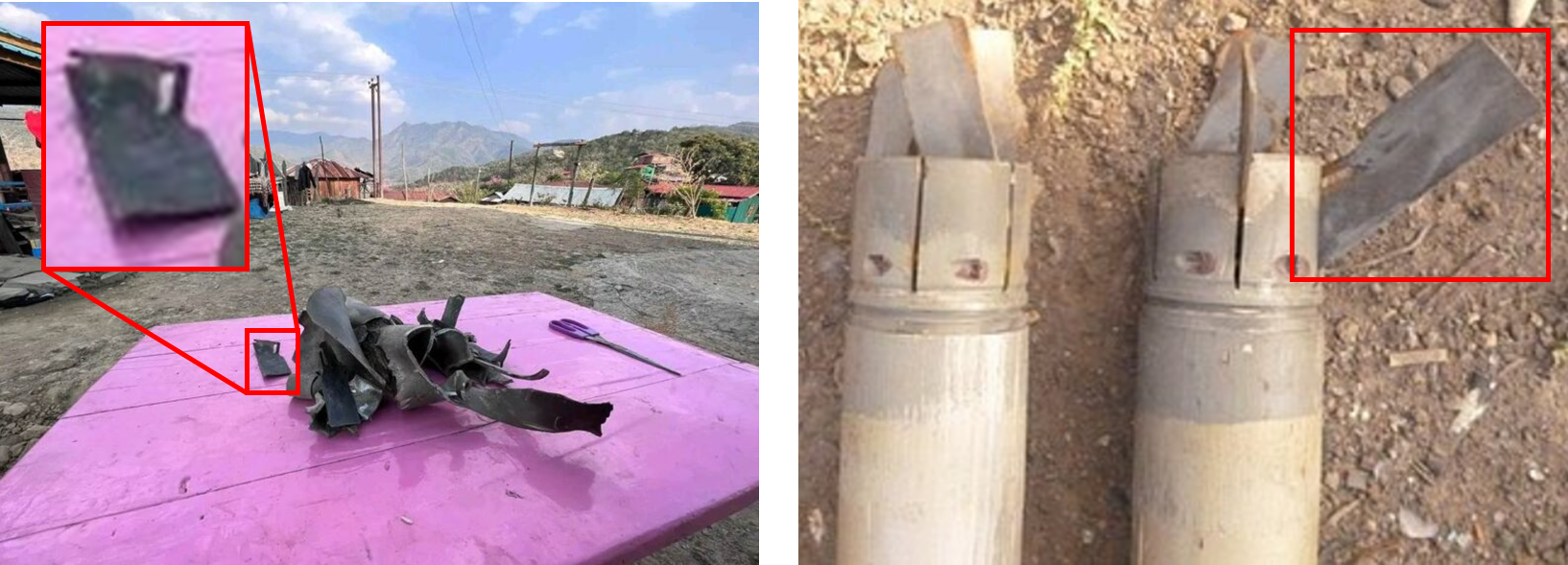
Figure 10: Visual comparison of remnants from Khuafo (left) to confirmed S-8-type rockets’ fins sections (right) – sources: The Chin Journal; Myanmar Witness.
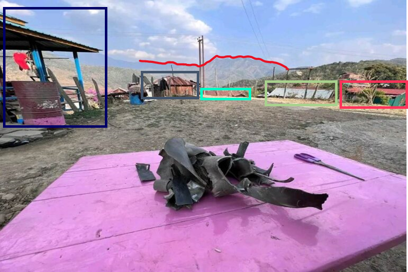
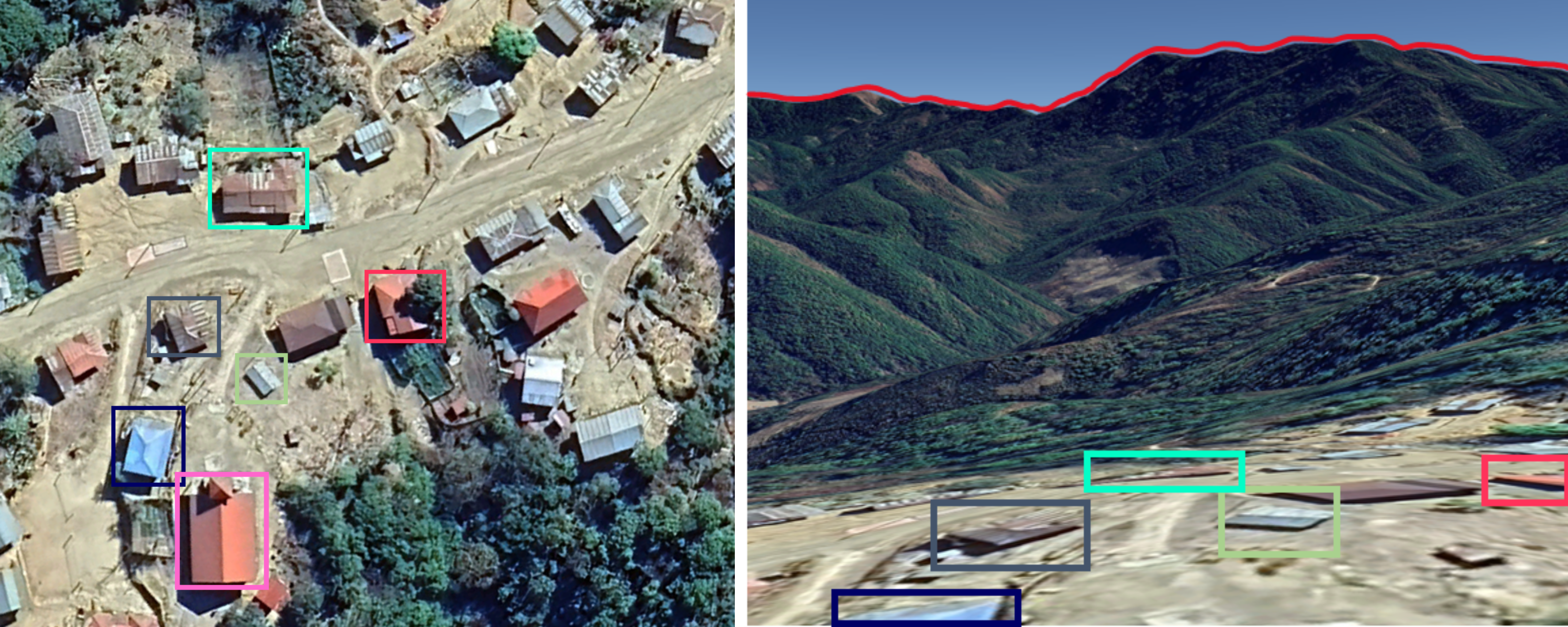
Figure 11: Geolocation and UGC reportedly showing debris from an S-8-type rocket in front of the Khuafo Baptist Church (shown in the pink box) [22.751822, 93.425291] (sources: The Chin Journal; Myanmar Witness).
The destruction of additional residential buildings is demonstrated in further UGC. Footage shows sizable craters near houses, which appear to have sustained extensive structural damage (see Figure 12 on the following page). Though Myanmar Witness cannot verify that the destruction of residential property is linked to the alleged airstrike, the presence of craters supports the allegation that powerful explosive weapons were the likely cause of damage in the village.
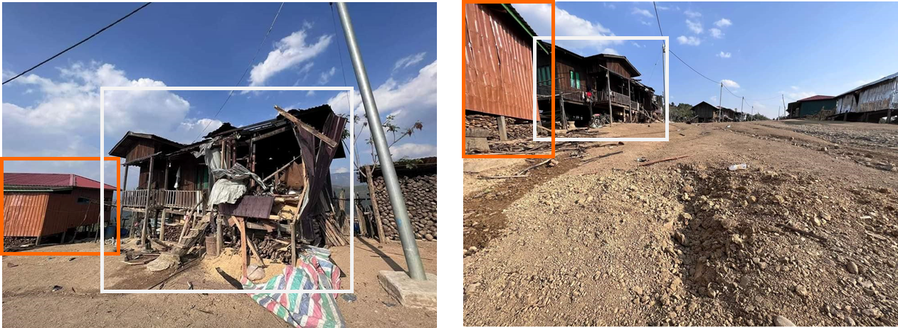
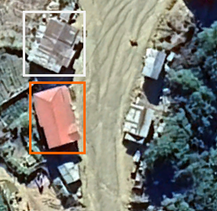
Figure 12: Geolocation of UGC reportedly showing a crater nearby destroyed residential houses [22.750288, 93.425819] (source: personal Facebook account, redacted due to privacy concerns).
2. The Presbyterian Church of Myanmar – Tlanglo
Thantlang, Chin, 27 April 2023
On 27 April 2023 at 1530 local time, it was reported that a MAF Yak-130 fighter jet conducted an airstrike on Tlanglo (တလန်လို) village [23.008120, 93.336327], approximately two miles from the Indian border. Khit Thit Media claimed that two civilians were killed and around 30 residential buildings were destroyed as a result of the alleged attack. The Chin Journal claimed that three church buildings were damaged due to the reported airstrike.
Myanmar Witness has geolocated UGC, which appears to show significant structural damage to the Presbyterian Church of Myanmar and surrounding houses (see Figure 13 below). Since the footage cannot be chronolocated due to a lack of clear satellite imagery, Myanmar Witness was unable to verify when the attack occurred, though the UGC analysed in the following pages was all shared on or shortly after the claimed date.
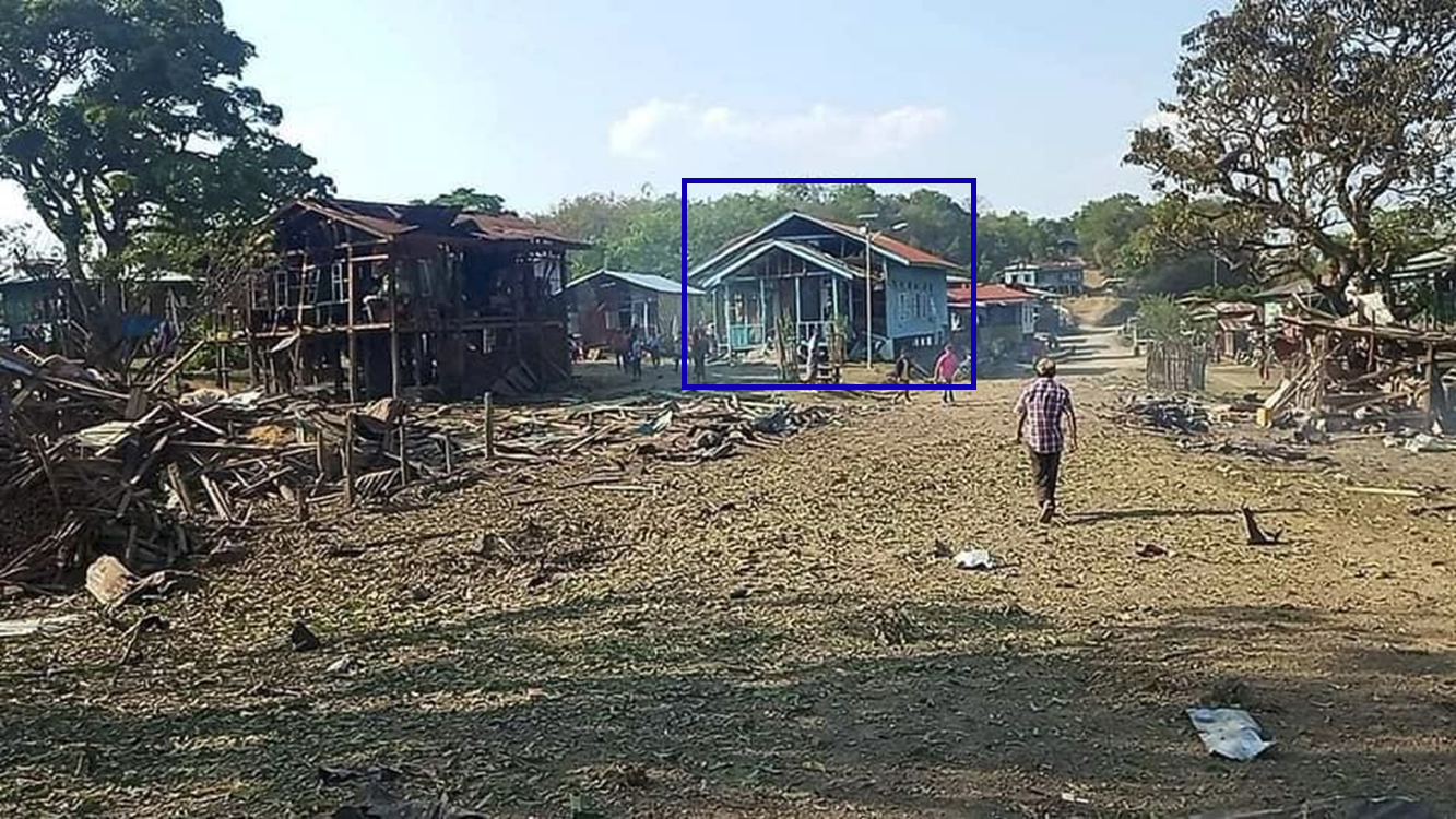
Figure 13: Myanmar Witness geolocated UGC showing damage to buildings in Tlanglo Village, including the Presbyterian Church of Myanmar, shown here in the navy box [23.008634, 93.337030] (source: Presbyterian Church of Myanmar – General Assembly).
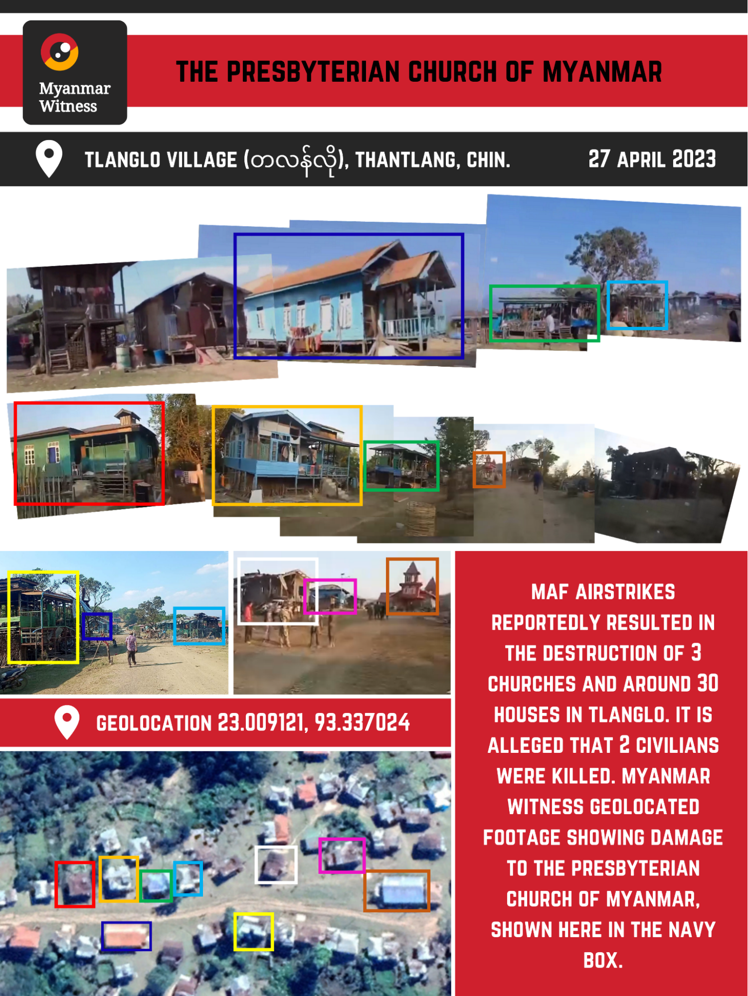
Figure 14: Graphic of geolocated UGC allegedly depicting the aftermath of an airstrike on Tlanglo village (sources: The Chin Journal; Global Tlanglo Youth Organization; Presbyterian Church of Myanmar – General Assembly).
Analysing the incident
The Chin Journal released a video allegedly showing the aftermath of the attack. Myanmar Witness geolocated this footage and analysed visible damage to the exterior of a large blue building. The Presbyterian Church of Myanmar claimed that this building was a branch of their church; this was corroborated by Google Maps data.
UGC shows extensive structural damage to the front of the church. The south-facing wall appears to have been destroyed, while the corrugated roof shows signs of warping. One photo, shared by the Presbyterian Church of Myanmar General Assembly, offers a view inside the church through the destroyed front wall (see Figure 15 below). This image appears to show significant damage to the interior of the building, while the rear wall also appears to have been destroyed.
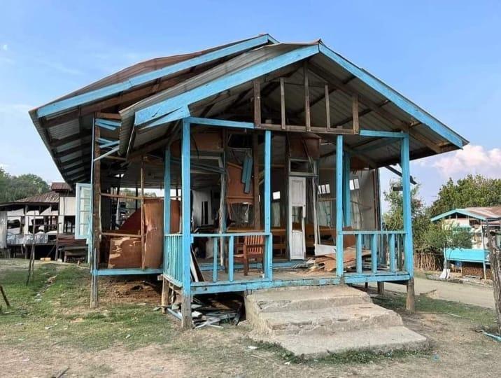
Figure 15: UGC shows damage apparently sustained to the Tlanglo branch of the Presbyterian Church of Myanmar following the alleged airstrike on the village [23.009121, 93.337024] (sources: The Chin Journal; Presbyterian Church of Myanmar – General Assembly).
Myanmar Witness also verified damage to residential buildings in Tlanglo. UGC appears to show large piles of timber and rubble, allegedly resulting from the destruction of houses (see Figure 16 below).
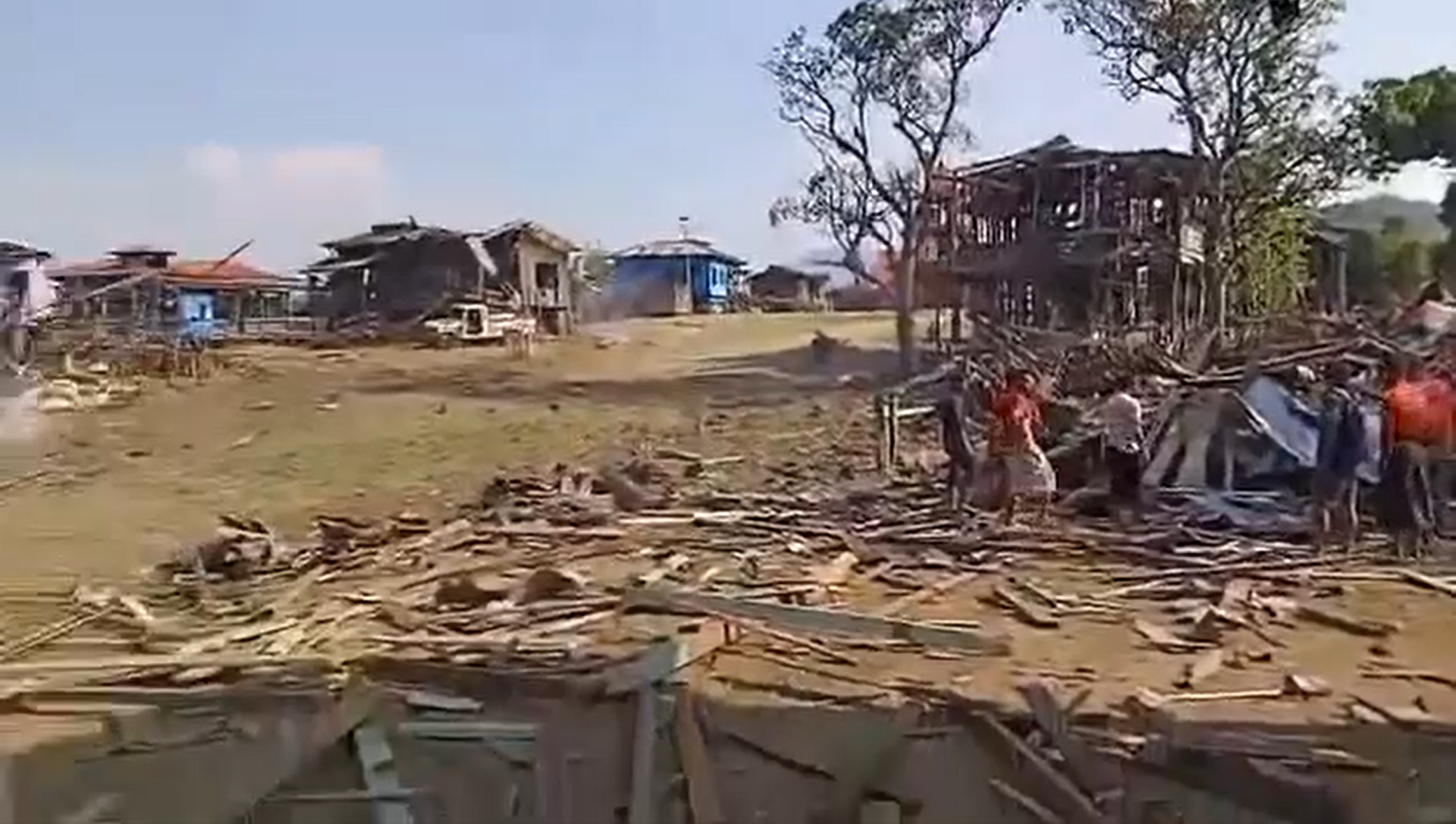
Figure 16: UGC appears to show a large pile of rubble apparently resulting from the bombing of residential buildings [23.008992, 93.337001] (source: Chindwin News Agency).
Video footage shared on the day of the reported airstrike appears to show two sizable craters in the middle of the main road through the village (see Figure 17 below). Myanmar Witness was not able to verify the occurrence of an airstrike on 27 April due to a lack of UGC showing aircraft in the vicinity. However, given the presence of craters and the extent of structural damage visible across Tlanglo, an aerial bombardment is a likely cause.

Figure 17: Footage appears to show 2 large craters in the middle of the main road running through Tlanglo village (source: Global Tlanglo Youth Organization – GTYO).
Though the Presbyterian Church of Myanmar was the only religious building where damage was verified in Tlanglo village, it was alleged that two other places of worship within the village were also damaged. Myanmar Witness used Google Maps data combined with the UGC to identify Tlanglo Baptist Church (see Figure 18 on the following page). However, Myanmar Witness was unable to verify damage to this structure.

Figure 18: Tlanglo Baptist Church (shown here in the brown box) is visible in UGC shared on the day of the alleged airstrike. Owing to the low resolution of this footage, Myanmar Witness was unable to verify damage to the church building [23.008091, 93.336918] (source: Global Tlanglo Youth Organization – GTYO).
3. Malsawm Baptist Church
Hakha, Chin, 5 May 2023
On 5 May 2023 at approximately 1020 local time, the MAF allegedly conducted an airstrike which hit the village of Malsawm (မာလ်ဆောမ်) [22.515184, 93.781898], Hakha township. It is alleged that the Baptist church was damaged after Myanmar military fighter jets dropped six bombs. No casualties were reported.
The Chin Journal claimed that following the airstrikes, troops from the SAC’s Light Infantry Division (LID) 77 occupied the village for four nights, leaving on 9 May. It is alleged that soldiers looted several buildings, including Malsawm Baptist Church.
While Myanmar Witness has been unable to verify that an airstrike occurred, UGC was geolocated which shows significant damage to the Baptist Church (see Figure 20 on the following page). Myanmar Witness has identified additional footage which allegedly shows the aftermath of looting. However, this claim has not been verified due a lack of identifiable features in the UGC.
Further claims stated that Believers Church Malsawm was occupied and ransacked by SAC troops. Footage shared by a personal Facebook account allegedly shows the aftermath of troop presence. Myanmar Witness has geolocated this imagery, however, the date and time of the footage could not be verified through chronolocation.
Due to the limited range of UGC depicting Believers Church, this case study has focussed on damage to Malsawm Baptist Church.
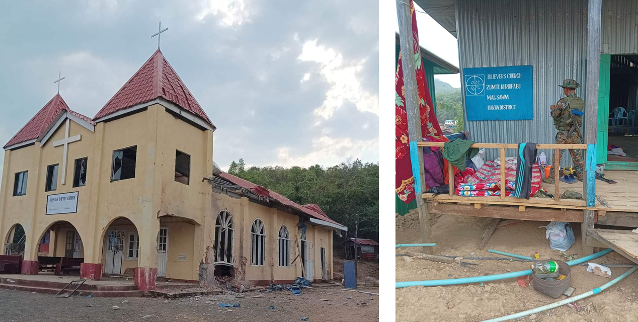
Figure 19: Footage shared by The Chin Journal shows extensive damage to Malsawm Baptist Church (left), which can be identified by the sign above its main entrance. Additional UGC shows the aftermath of the alleged military occupation of Believers Church Malsawm (right) (source: The Chin Journal; personal Facebook account, redacted due to privacy concerns).
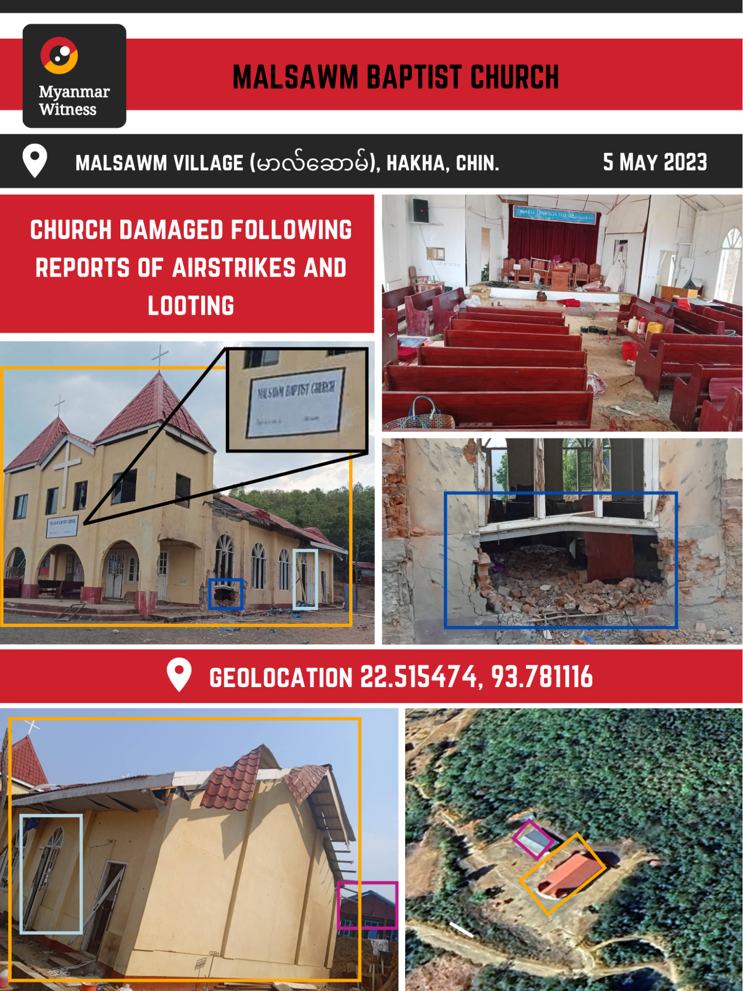
Figure 20: Graphic of geolocated UGC from Malsawm Baptist Church [22.515474, 93.781116] (sources: Chin Human Rights Organization; The Chin Journal).
Analysing the incident
UGC shared online on 5 May 2023 shows extensive damage to a church. One of the photos shared by The Chin Journal shows a sign above the entrance, identifying the building as Malsawm Baptist Church (see Figure 20 above).
Myanmar Witness geolocated UGC which purports to show the aftermath of the attack and reveals the extensive damage to the Baptist Church. Myanmar Witness cannot verify the multiple independent claims of an airstrike related to this incident, due to a lack of UGC showing armed aircraft in the vicinity. However, structural damage of this severity is consistent with damage seen in other locations where airstrikes have been verified by Myanmar Witness, such as those documented in the Eyes on the skies report. Given the extent of the structural damage to the brick building, a large calibre ordnance was likely employed. The impact appears to have sprayed shrapnel upwards both to the left and to the right of the visible impact point (see Figure 21 left-hand image below).
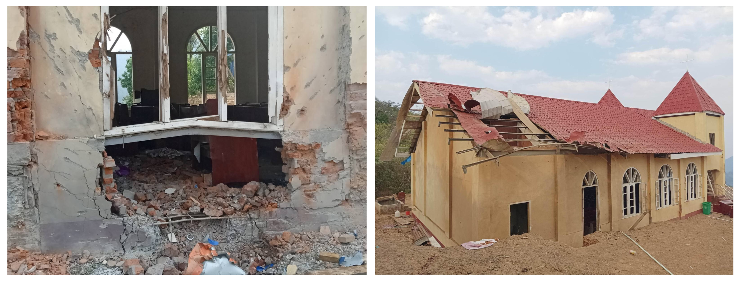
Figure 21: Geolocated UGC showing structural damage to the exterior wall and roof of Malsawm Baptist Church (sources: Chin Human Rights Organization; personal Facebook account, redacted due to privacy concerns).
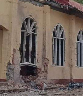
Figure 22: Footage appears to show burn marks around the damaged window of Malsawm Baptist Church (source: The Chin Journal).
Several images released on Facebook alongside images of the damaged Malsawm Baptist Church appear to show clothes and other domestic objects strung across the floors of various buildings (see Figure 23 below). According to the social media user, these images show how the buildings were left by military personnel after they were looted. Myanmar Witness was unable to geolocate these images due to the lack of identifiable features.
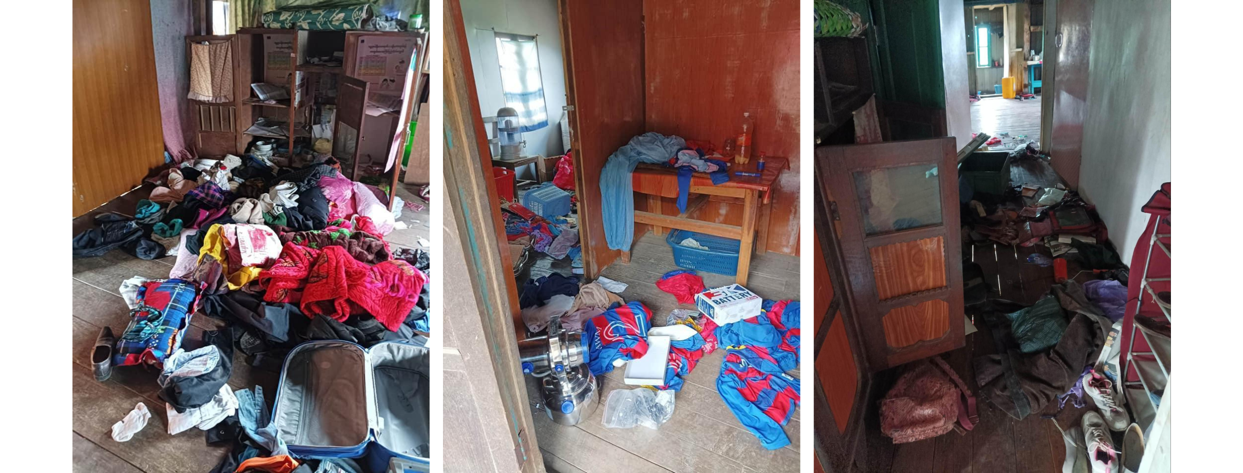
Figure 23: It is alleged that these images show the aftermath of the SAC occupation of Malsawm. Myanmar Witness has not been able to verify the claim that soldiers ransacked buildings in the village (source: personal Facebook account, redacted due to privacy concerns.)
The Chin Journal claimed that in addition to Malsawm Baptist Church, troops from LID 77 occupied and ransacked Believers Church. Myanmar Witness analysed images shared by a personal Facebook account on 11 May, which depict Believers Church Malsawm [22.514620, 93.781223] (see Figure 24 on the following page). The source of these images has been redacted due to privacy concerns. Using earlier imagery shared by the same account, it was possible to identify and geolocate distinctive features such as the blue sign and painted support poles (see Figure 25 on the following page).
The UGC appears to show temporary beds at the church entrance, possibly for a night guard. Clothes and other personal effects are strung over the railings, indicating that the church was likely being used for non-religious purposes. UGC also shows scattered objects in the interior of the building, again suggesting that the church was used for temporary shelter. However, since chronolocation was not possible for this UGC, Myanmar Witness was unable to verify a military presence at the alleged time in Believers Church Malsawm.
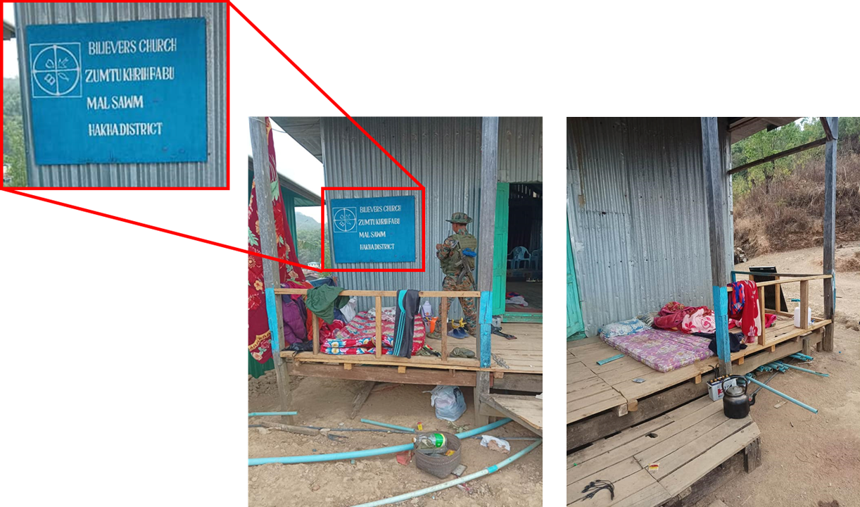
Figure 24: Geolocated UGC allegedly showing the impact of military presence in Believers Church Malsawm. Myanmar Witness has been unable to verify the allegiance of the soldier visible in the left-hand image (source: personal Facebook account, redacted due to privacy concerns).
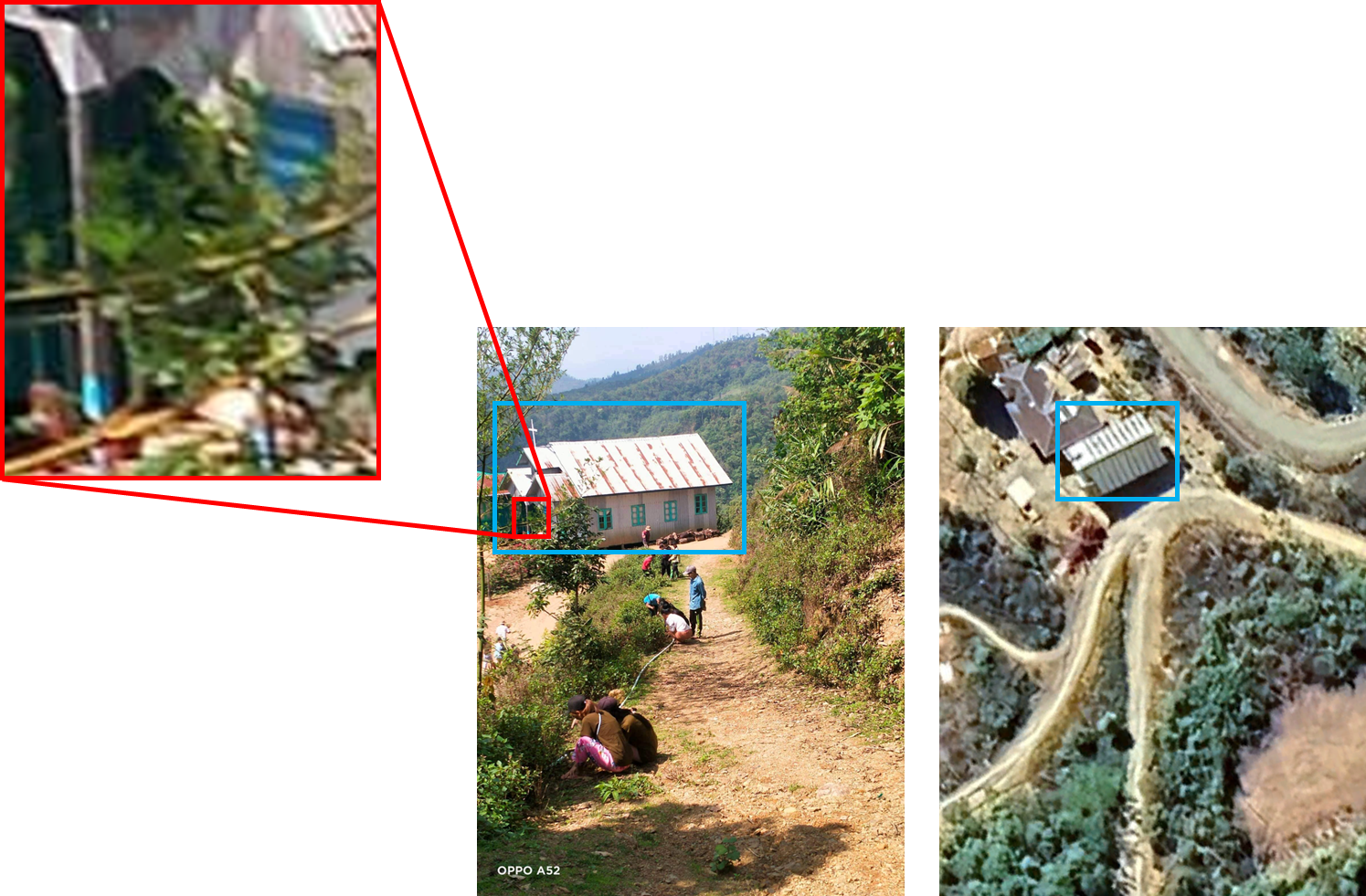
Figure 25: A reference photo shared in May 2022 allowed investigators to geolocate the UGC showing Believers Church Malsawm. The blue sign and distinctive painted poles are visible. Features such as the cross above the entrance identify the structure as a Christian church [22.514909, 93.781262] (source: personal Facebook account, redacted due to privacy concerns).
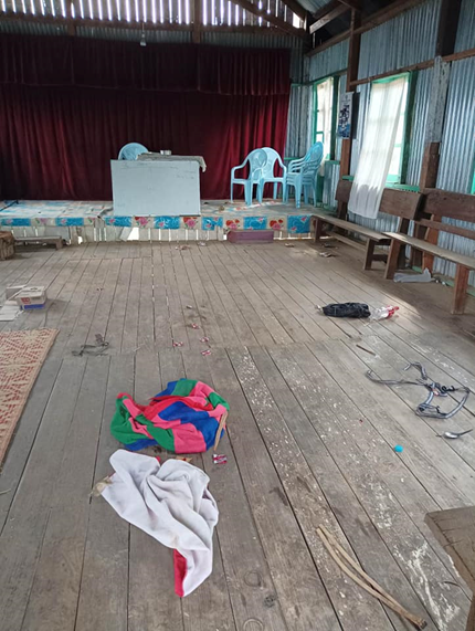
Figure 26: After the alleged military presence in Believers Church Malsawm, footage was shared of the interior. Myanmar Witness was unable to verify that the scattered objects visible in this imagery were linked to claims of looting or SAC occupation (source: personal Facebook account, redacted due to privacy concerns).
4. Ramthlo Baptist Church
Falam, Chin, 12 August 2023
On 12 August 2023 at around 1100 local time, Khit Thit Media claimed (warning: graphic link) that an MAF fighter jet dropped two bombs on Ramthlo (ရမ်ထလို) village [22.825451, 93.560120], Falam township, injuring seven civilians. Ramthlo Baptist Church reportedly sustained a direct hit, and it is alleged that several nearby houses were destroyed. Myanmar Witness has geolocated timestamped UGC, which shows significant interior and exterior damage to Ramthlo Baptist Church (see Figure 28 on the following page). Myanmar Witness could not verify the timestamps as cloud cover obscured satellite imagery, preventing chronolocation from taking place.
The Chin Human Rights Organization alleged that the bombing coincided with artillery
strikes, which also hit the village. It is claimed (warning: graphic link) that the incident came after a battle in Falam town when CNA troops attacked SAC forces in the early hours of 12 August.
The alleged attack on 12 August was the second report of military strikes in Ramthlo in 2023. On 6 April, SAC troops reportedly started fires in Ramthlo village. Then, on 10 April, MAF jets allegedly dropped six bombs on the village. FIRMS data from 6 April corroborates the claim of fires.
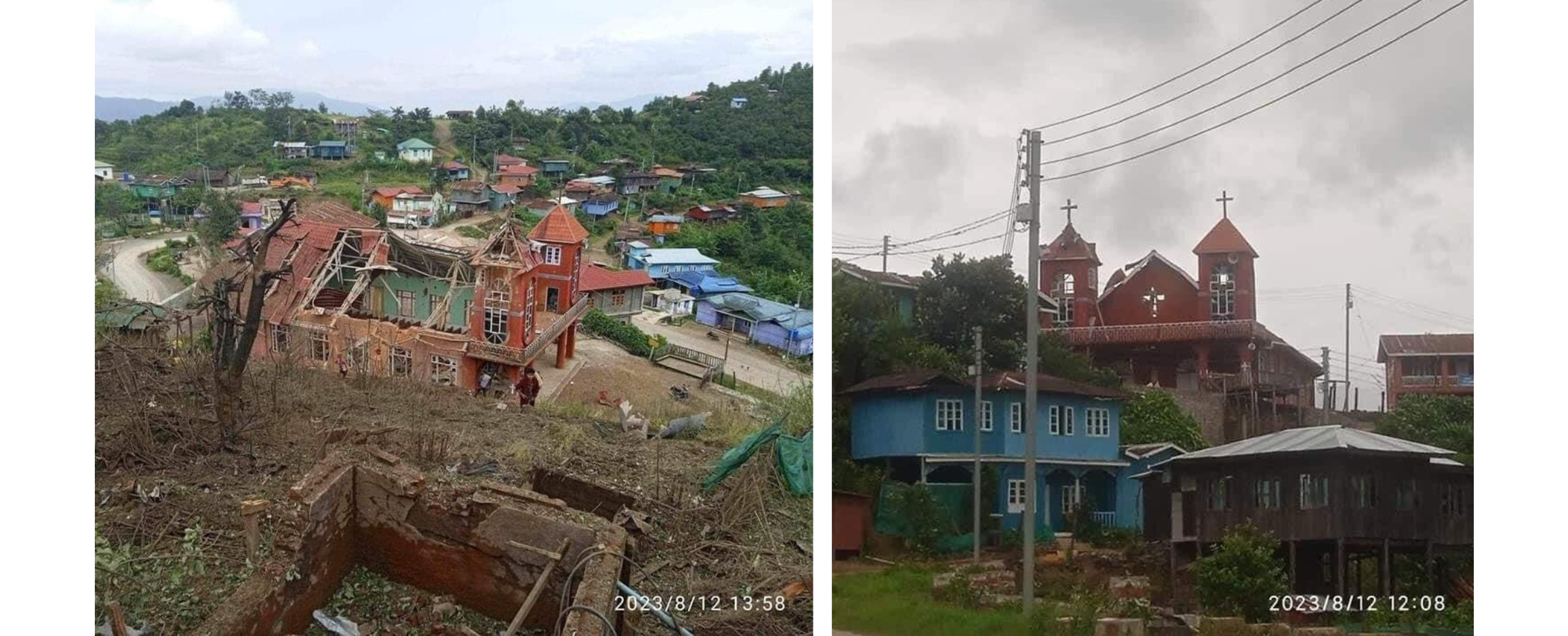
Figure 27: Timestamped UGC shows extensive structural damage to Ramthlo Baptist Church (sources: Burma Media Consortium; The Chin Journal, warning: graphic link).
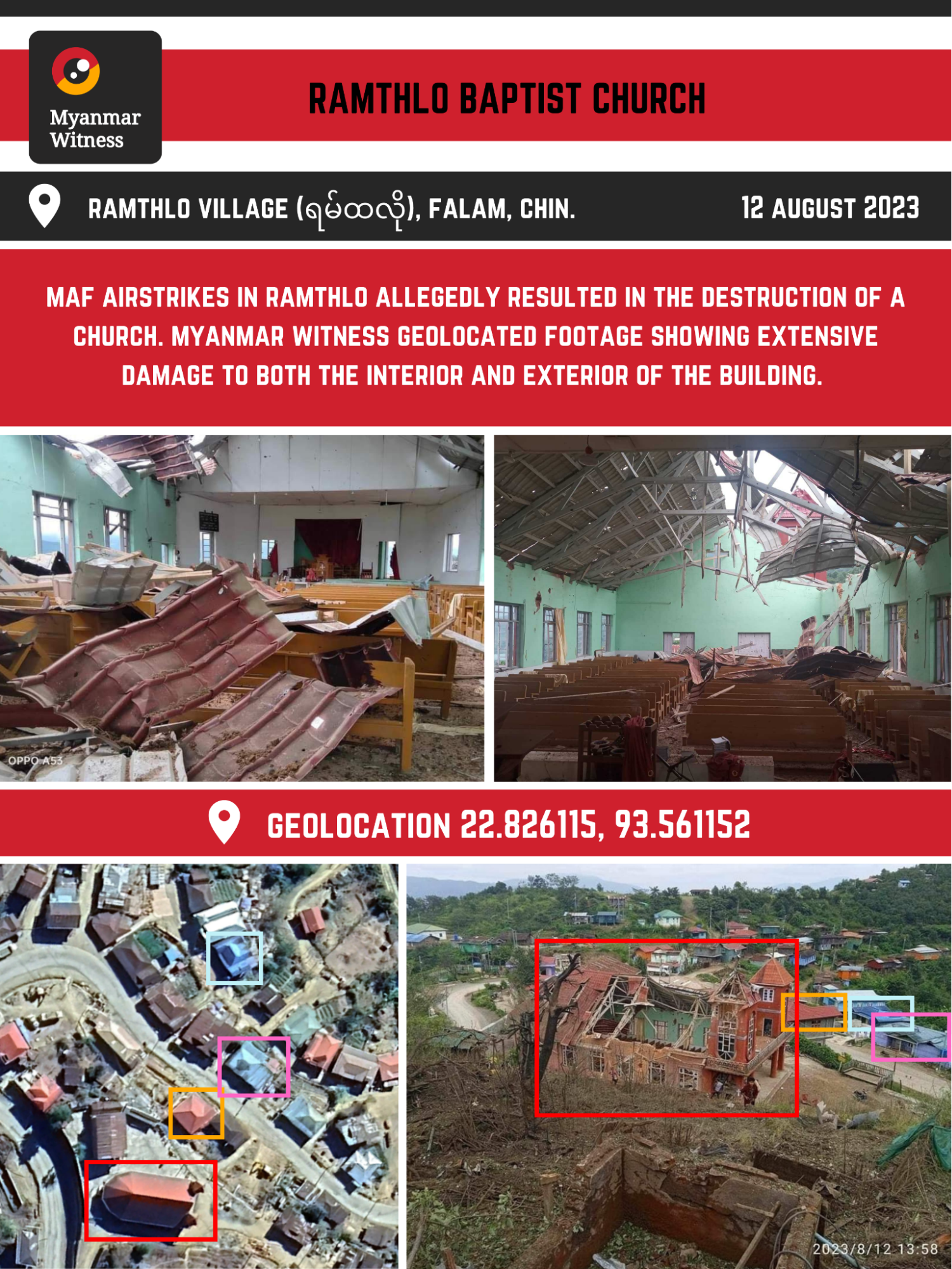
Figure 28: Graphic showing UGC which has been geolocated by Myanmar Witness to Ramthlo Baptist Church [22.826175, 93.561084] (source: Burma Media Consortium; Chin Human Rights Organization; personal Facebook account, redacted due to privacy concerns).
Analysing the incident
Khit Thit Media posted (warning: graphic link) imagery purporting to show the aftermath of the attack. Myanmar Witness verified that the images depict Ramthlo Baptist Church. UGC shows what appears to be a large hole in the west slope of the roof, as well as considerable damage to the towers and brickwork (see Figure 28 above).
Footage showing the interior of the building can also be tied to the Baptist Church as Myanmar Witness has identified multiple correlating pieces of information in the imagery . For example, the size and shape of the hole in the roof appears to be consistent with exterior images. Other features, such as the green wall, window frames and tower, are visible from both the interior and exterior views. Signage visible in one image identifies the building as Ramthlo Baptist Church (see Figure 29 below). UGC shows significant damage to pews and other church property, reportedly caused by fallen debris from the roof.
Several factors lend credibility to the allegation that Ramthlo Baptist Church was specifically targeted in this reported airstrike. Even from above, the religious function of the building is unambiguous, given its distinctive towers and round rear wall. The damage to the church’s roof appears to have been sustained by a large impact, consistent with claims of a direct hit. Although it appears that Ramthlo Baptist Church was targeted in this incident, it is not possible to establish motivation. As one of the largest buildings in the village and occupying a strategic position on higher ground, it may be that the structure was identified as a possible stronghold for local resistance. Alternatively, the reported attack may aim to diminish the morale of the Chin people, who are 85% Christian, by destroying a sacred communal building.
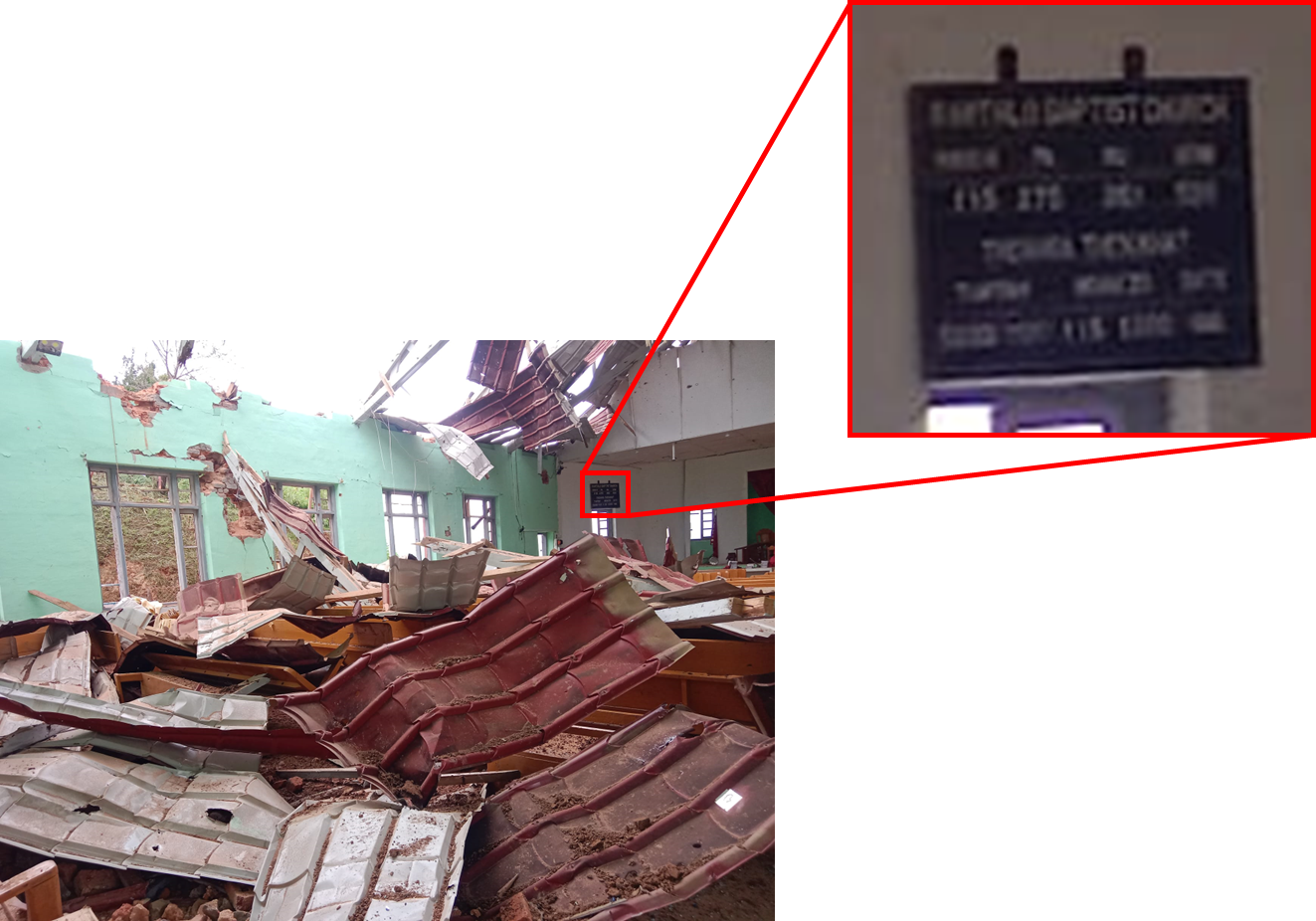
Figure 29: Signage visible in UGC identifies the building as Ramthlo Baptist Church. Debris appears to have fallen from the roof, damaging church pews and other property (source: personal Facebook account, redacted due to privacy concerns.)
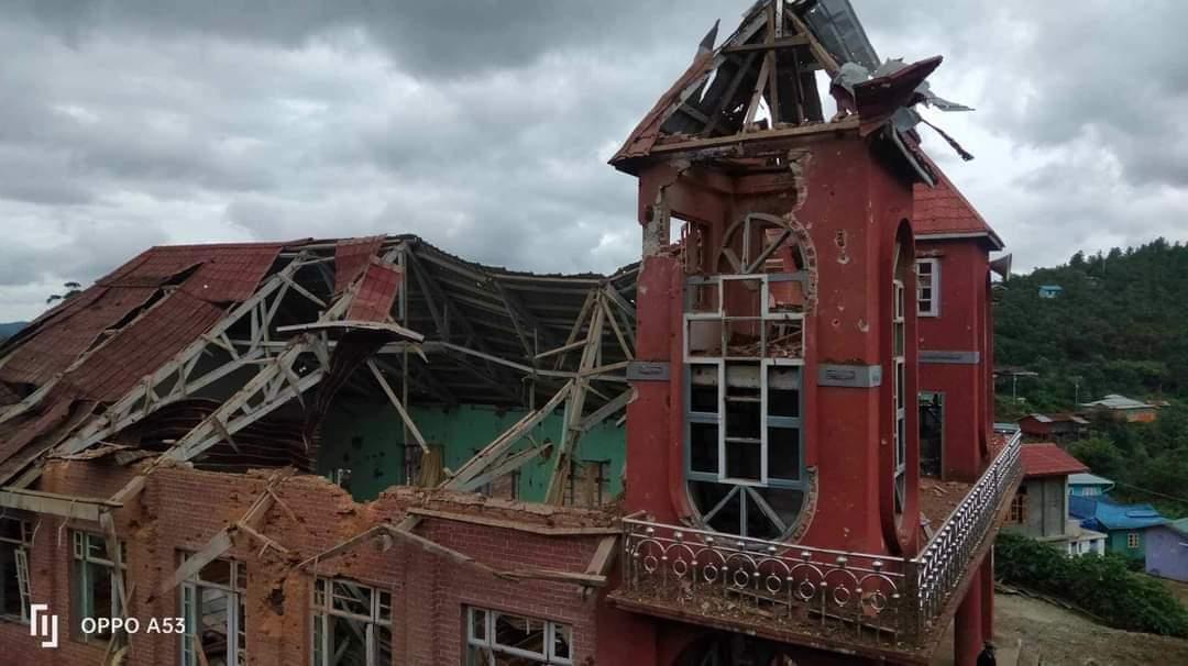
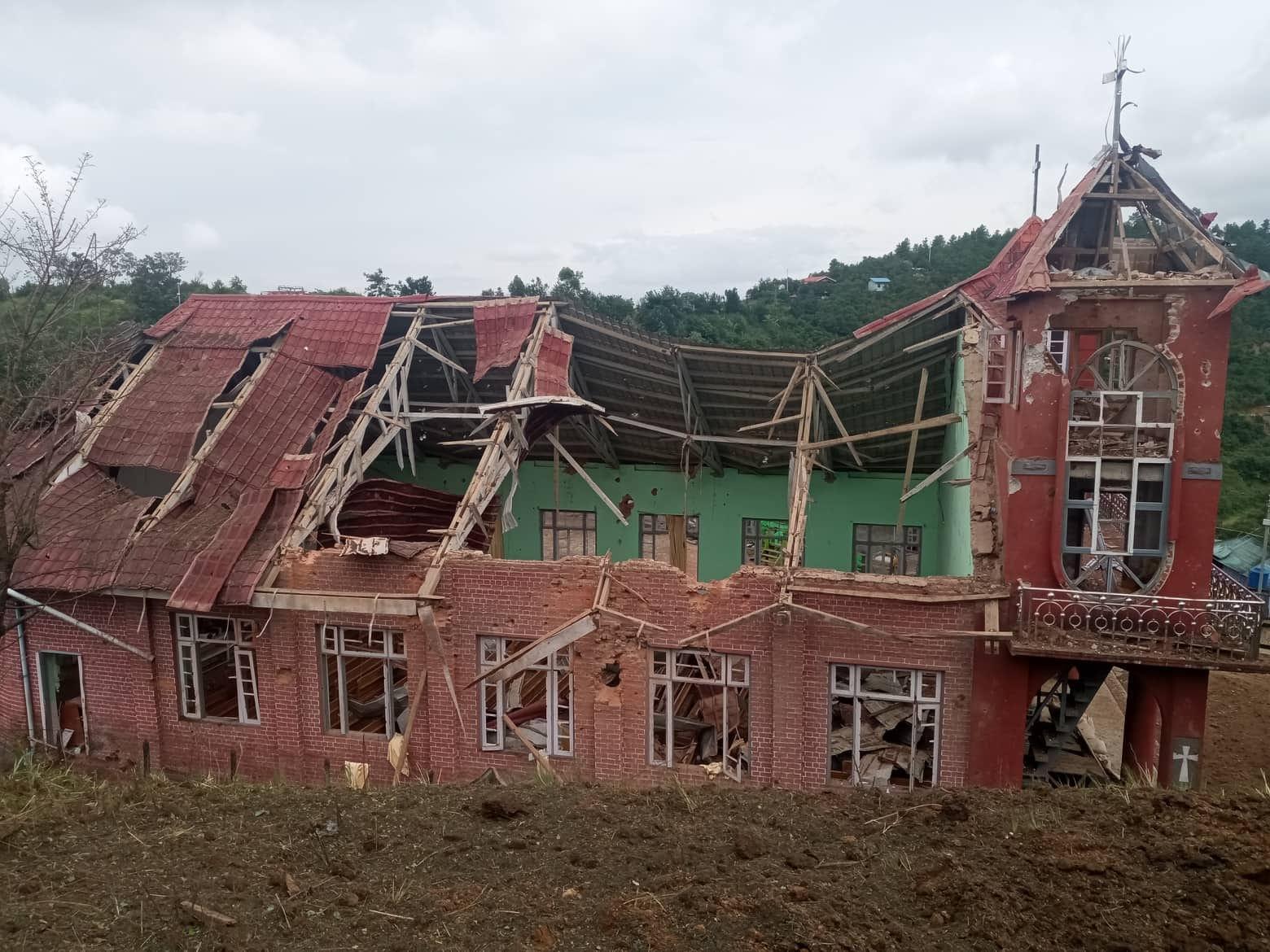
Figure 30: Footage shows a large hole in the roof of the church, in addition to structural damage to the towers and brickwork (sources: The Chin Journal, warning: graphic link; personal Facebook account, redacted due to privacy concerns.)
5. Khuafo Baptist Church
Thantlang, Chin, 14 August 2023
On 14 August 2023 at around 0500 local time, the MAF allegedly bombed the village of Khuafo (ခွါဖိုး) [22.751320, 93.425133]. Khit Thit Media claimed that Khuafo Baptist Church was damaged along with four residential houses. No casualties were reported. The attack allegedly occurred shortly after SAC troops were attacked by CNA-CDF joint forces in Thantlang, which is located approximately five miles south of Khuafo.
UGC surfaced in the following days, showing damage to the church and surrounding residential buildings. Myanmar Witness geolocated footage which allegedly shows the aftermath of the reported airstrike (see Figure 32 on the following page). Due to heavy cloud coverage, it was not possible to verify when the attack occurred. None of the UGC analysed below was published prior to 14 August, reducing the likelihood that any of the damage visible in these images was related to the earlier alleged airstrike on 30 March (see Case study 1).
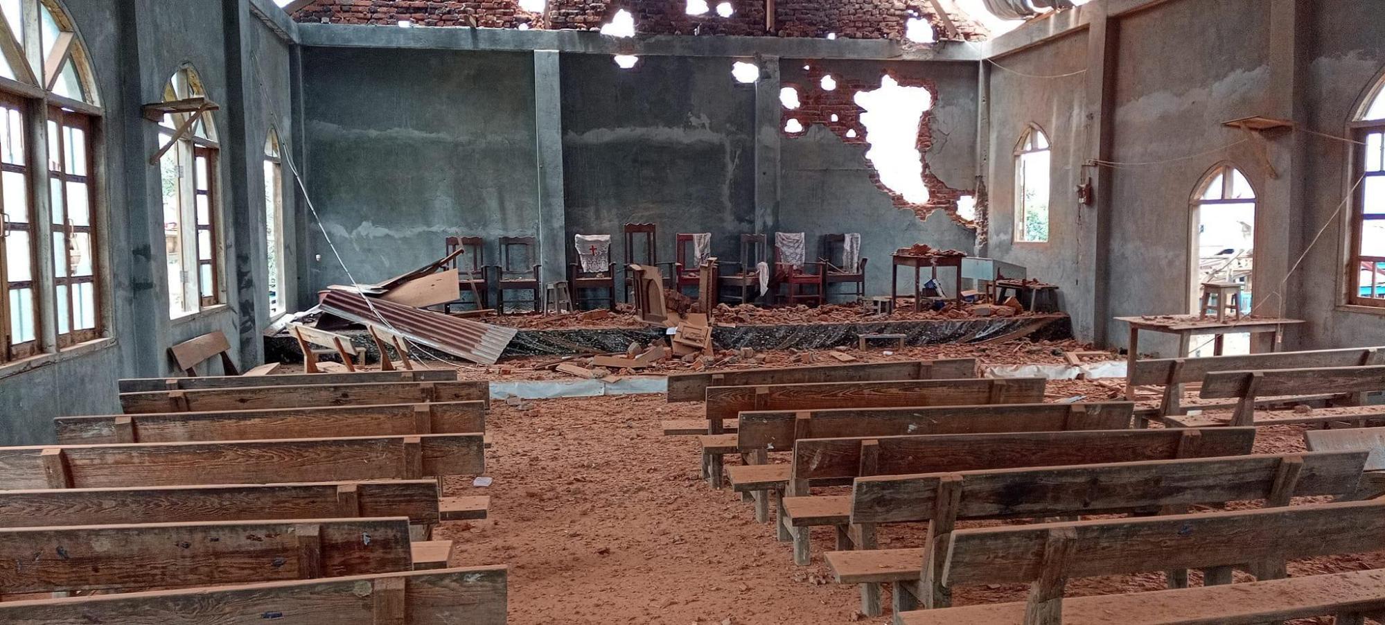
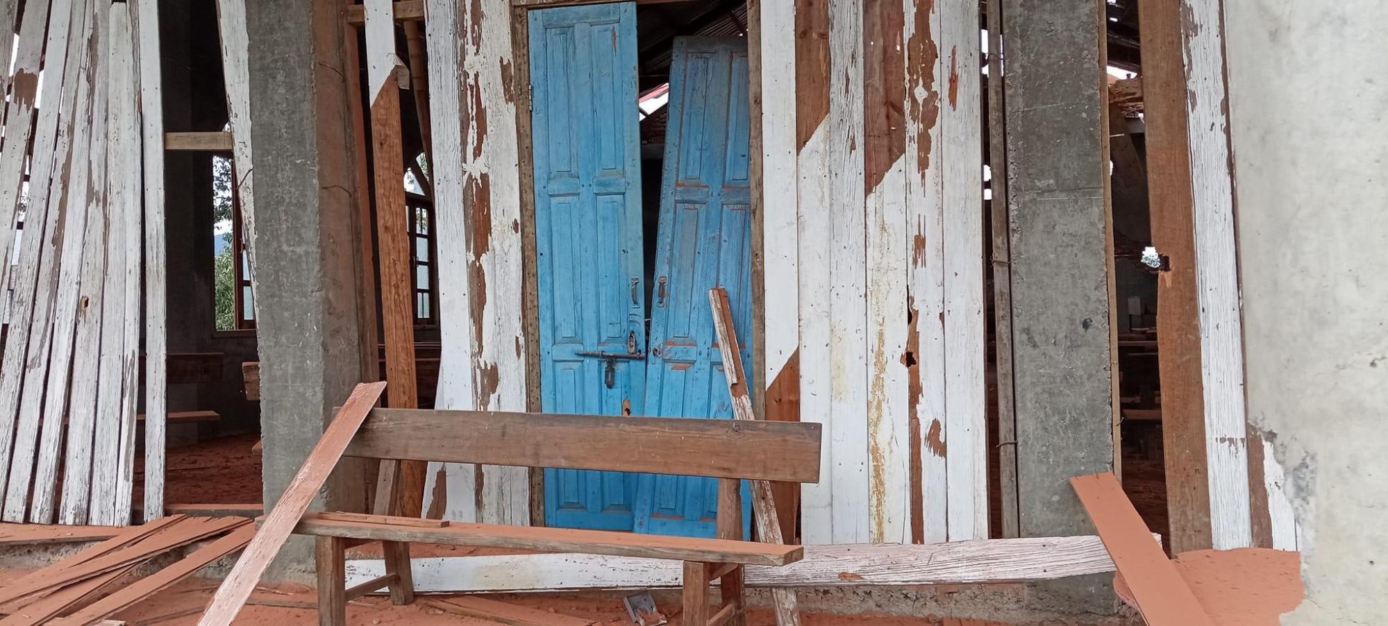
Figure 31: Imagery from the claimed airstrike on Khuafo. Damage to the interior of Khuafo Baptist Church (top), along with damage to the front door and walls of the church (bottom) (source: Khit Thit Media).
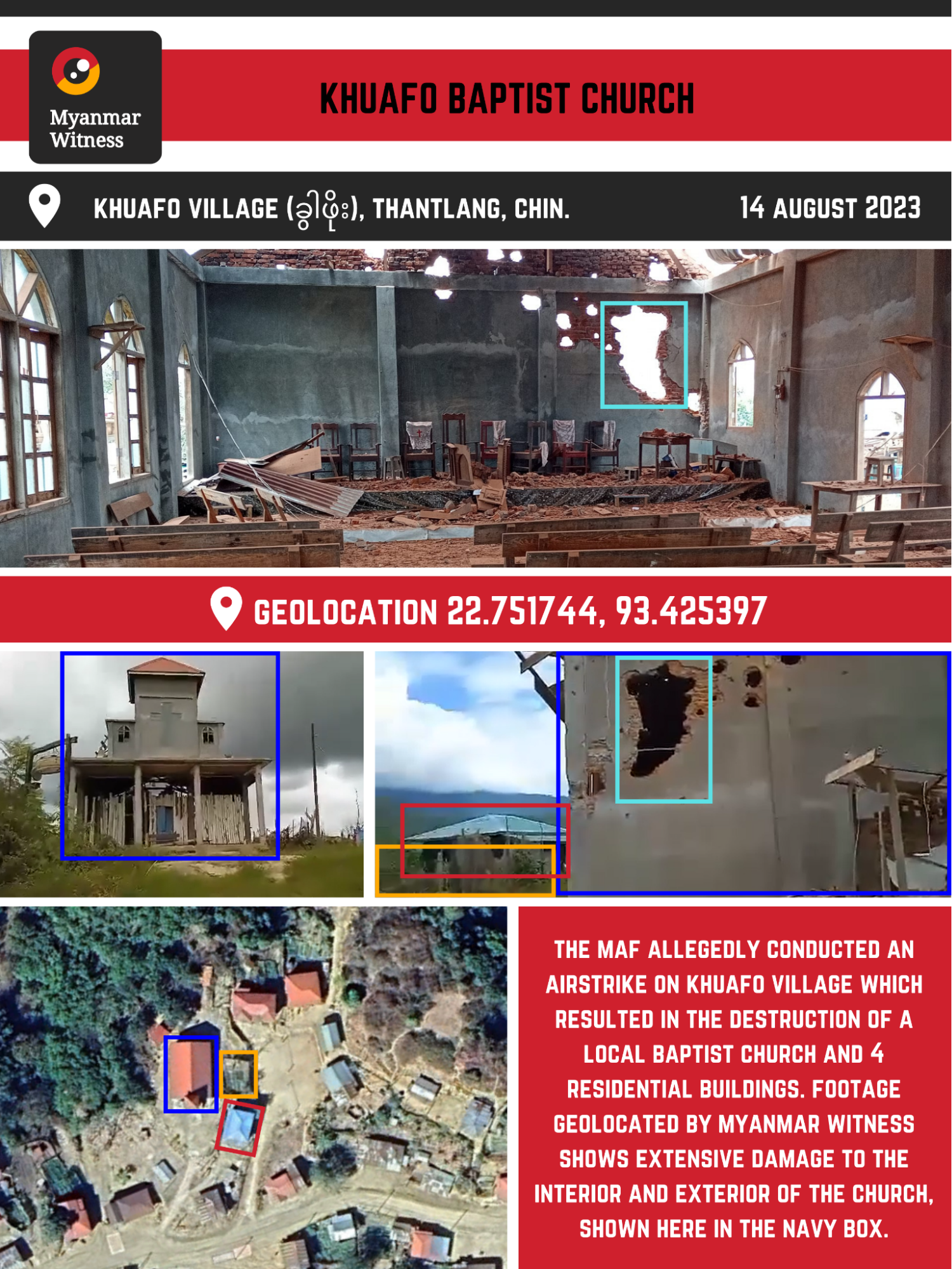
Figure 32: Graphic of geolocated UGC from Khuafo Baptist Church (sources: Khit Thit Media; The Independent Post).
Analysing the incident
Khit Thit Media released images purporting to show the aftermath of the attack. A video was also shared, which allowed investigators to locate the church and its surrounding buildings. Myanmar Witness confirmed that the footage shows various locations which sustained extensive damage near Khuafo Baptist Church.
Many images show a large hole in the church’s rear wall. Its distinctive outline is visible from both the interior and exterior. There is also significant damage to the building’s walls, door, windows, and roof.
UGC depicting the aftermath of the alleged incident shows a large crater behind the church. To the side of the crater, the footage appears to show that a residential building close to the church has been destroyed. Figure 33 below shows the crater in a green box, the residential building in magenta, and the rear of the church in navy.

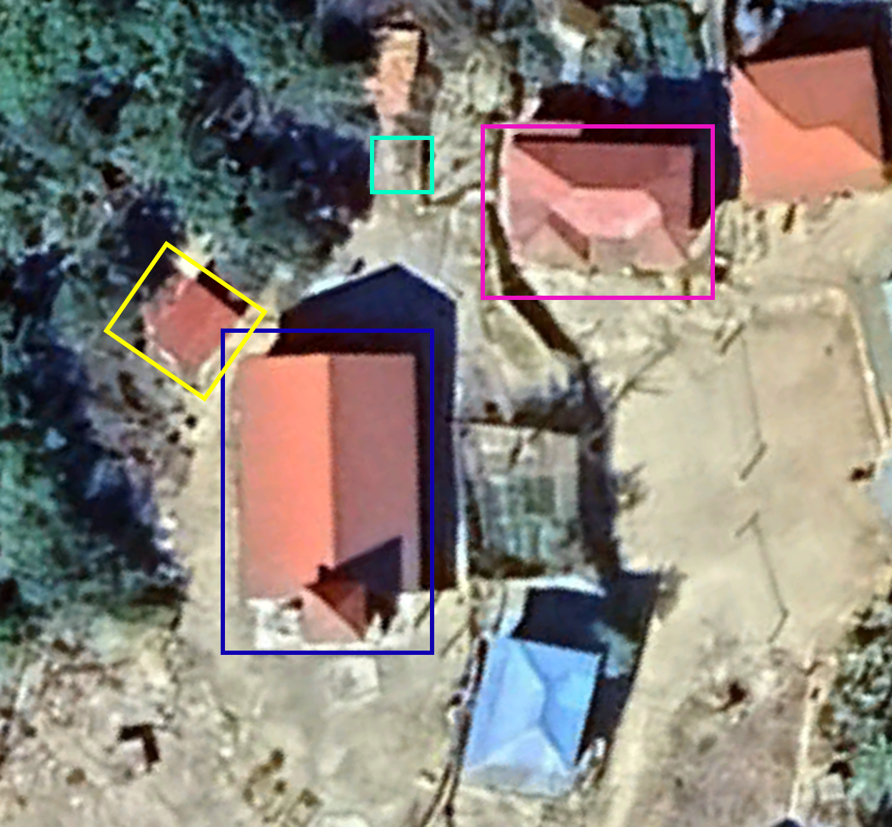
Figure 33: A video shared on the day of the alleged airstrike shows a large crater between Khuafo Baptist Church and a nearby residential building. Myanmar Witness created a panorama from this footage, which shows structural damage to both buildings. The video was then geolocated using satellite imagery from Google Earth (source: The Independent Post).
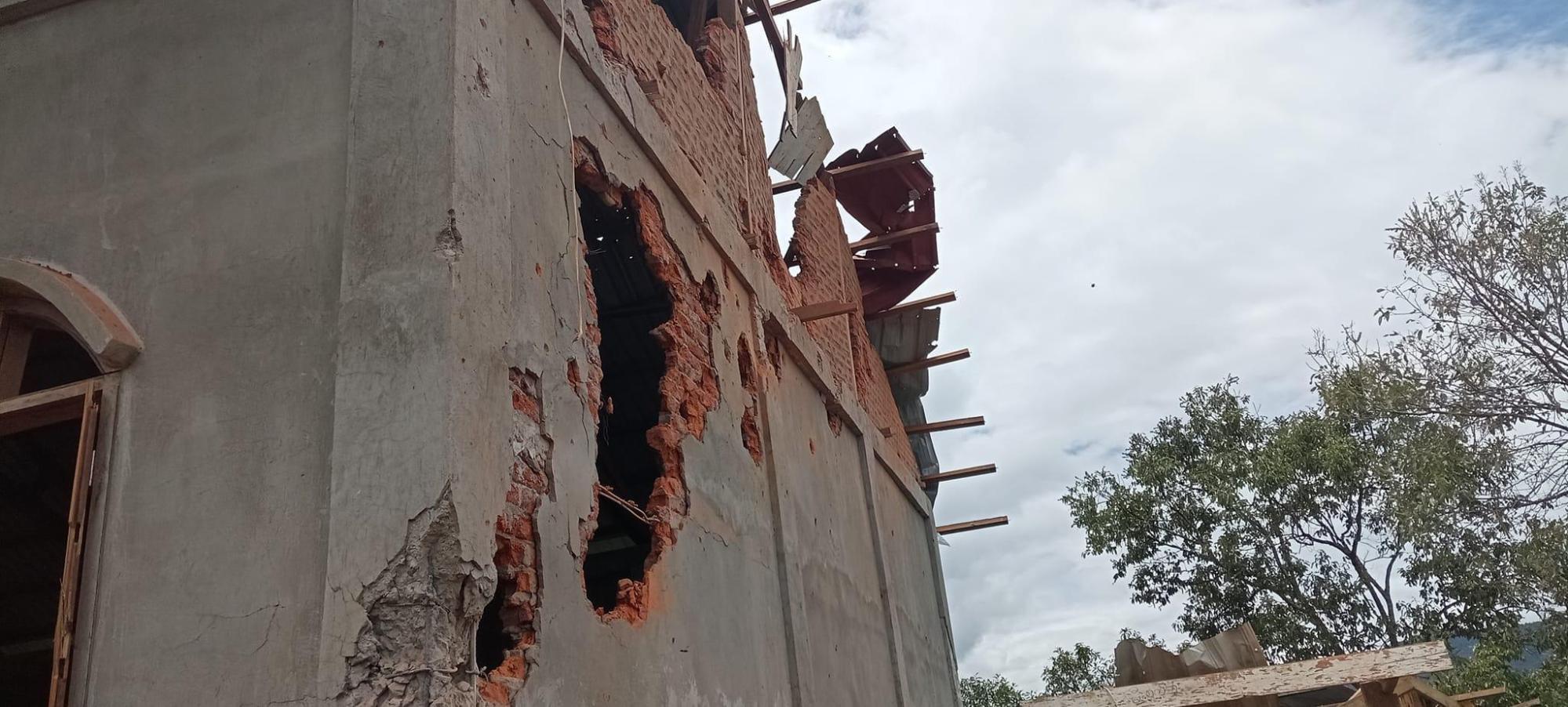
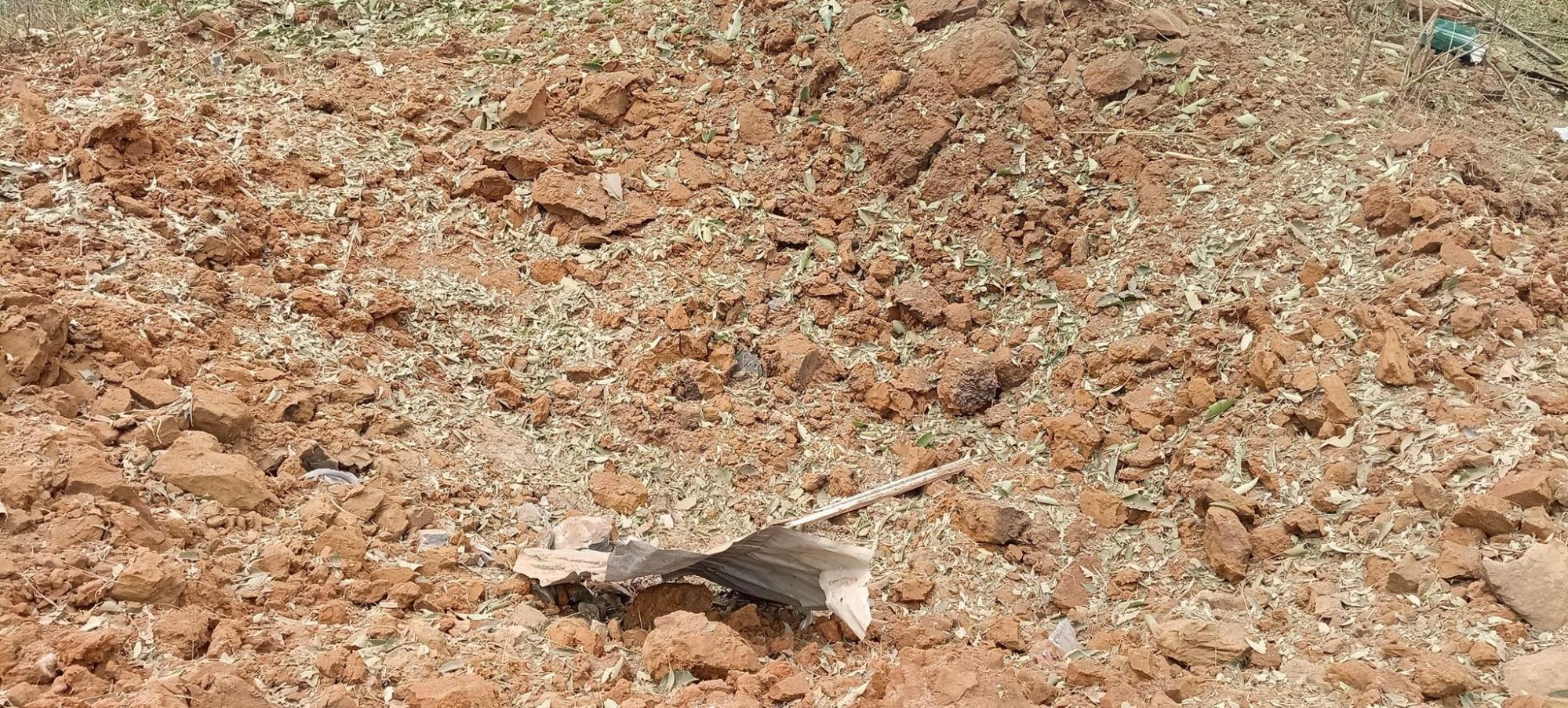
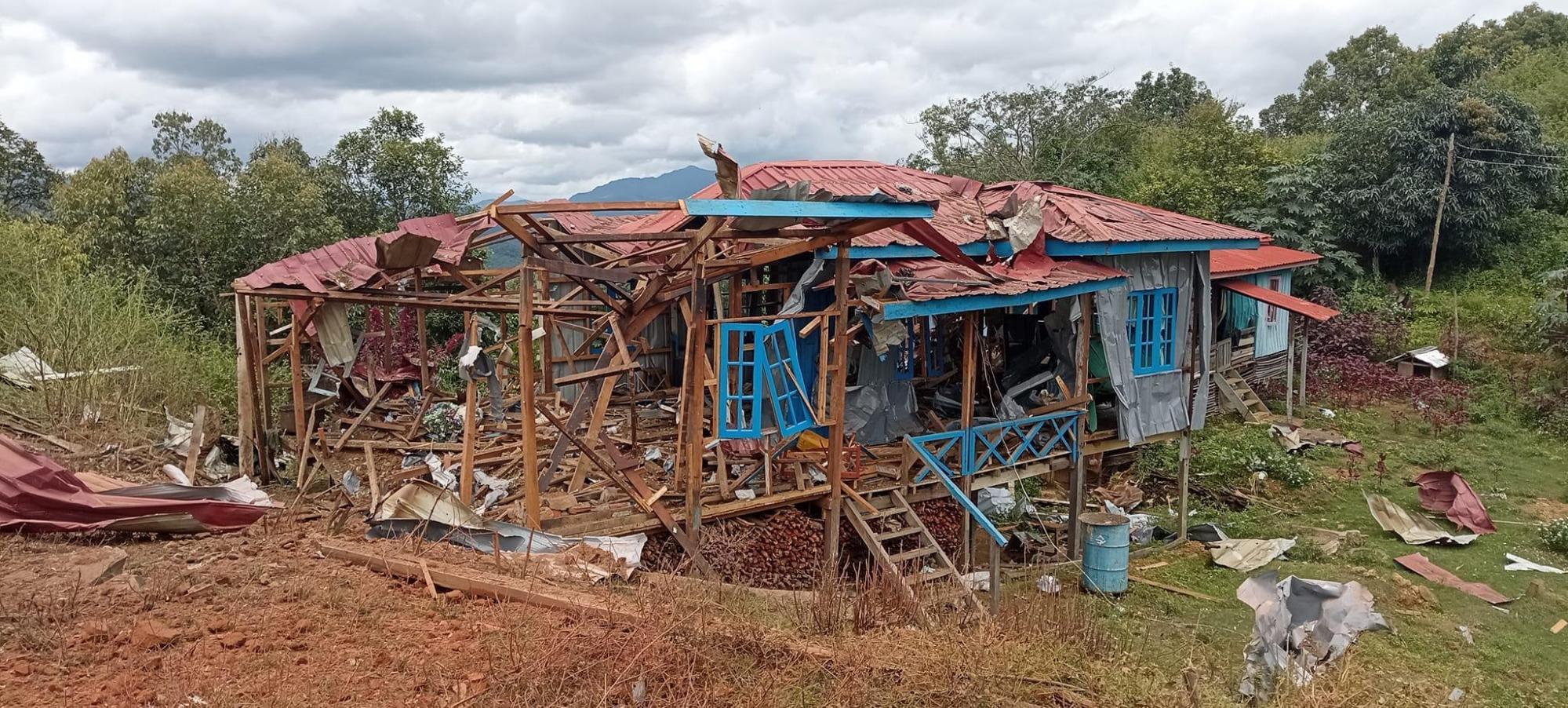
Figure 34: Images shared on the day of the alleged airstrike appear to show structural damage to the rear of Khuafo Baptist Church (top), a large crater in the ground behind the church (middle) and a destroyed residential building (bottom). This footage has been compared with a video also claiming to show the aftermath of the incident (see Figure 33) and has been geolocated by Myanmar Witness (source: Khit Thit Media).
Myanmar Witness was unable to verify that the damage depicted in UGC was caused by an airstrike on 14 August. However, the presence of a large crater could be consistent with the airstrike allegation. The extent of structural damage to Khuafo Baptist Church and a nearby residential building may support the claim that an explosive ordnance was responsible. Given that the most substantial damage (to the church’s rear wall and the front of the house) is in the direct vicinity of the crater, an explosion at this site is a likely cause. The large holes in the wall of the church may have been sustained as a result of shrapnel from the impact, however, heavy direct gunfire from air asset artillery could be an alternative explanation.
Additional UGC, shared by Khit Thit Media, shows structural damage to civilian buildings around Khuafo village (see figures 33 and 34 below). Myanmar Witness was again unable to verify the allegation of an aerial bombardment.
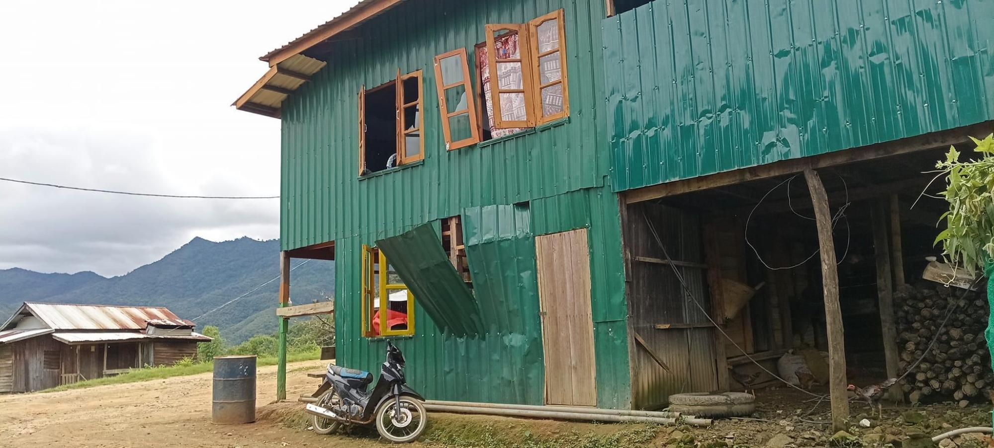
Figure 35: UGC showing damage to a residential building in Khuafo, geolocated by Mynmar Witness [22.751454, 93.425418] (source: Khit Thit Media).
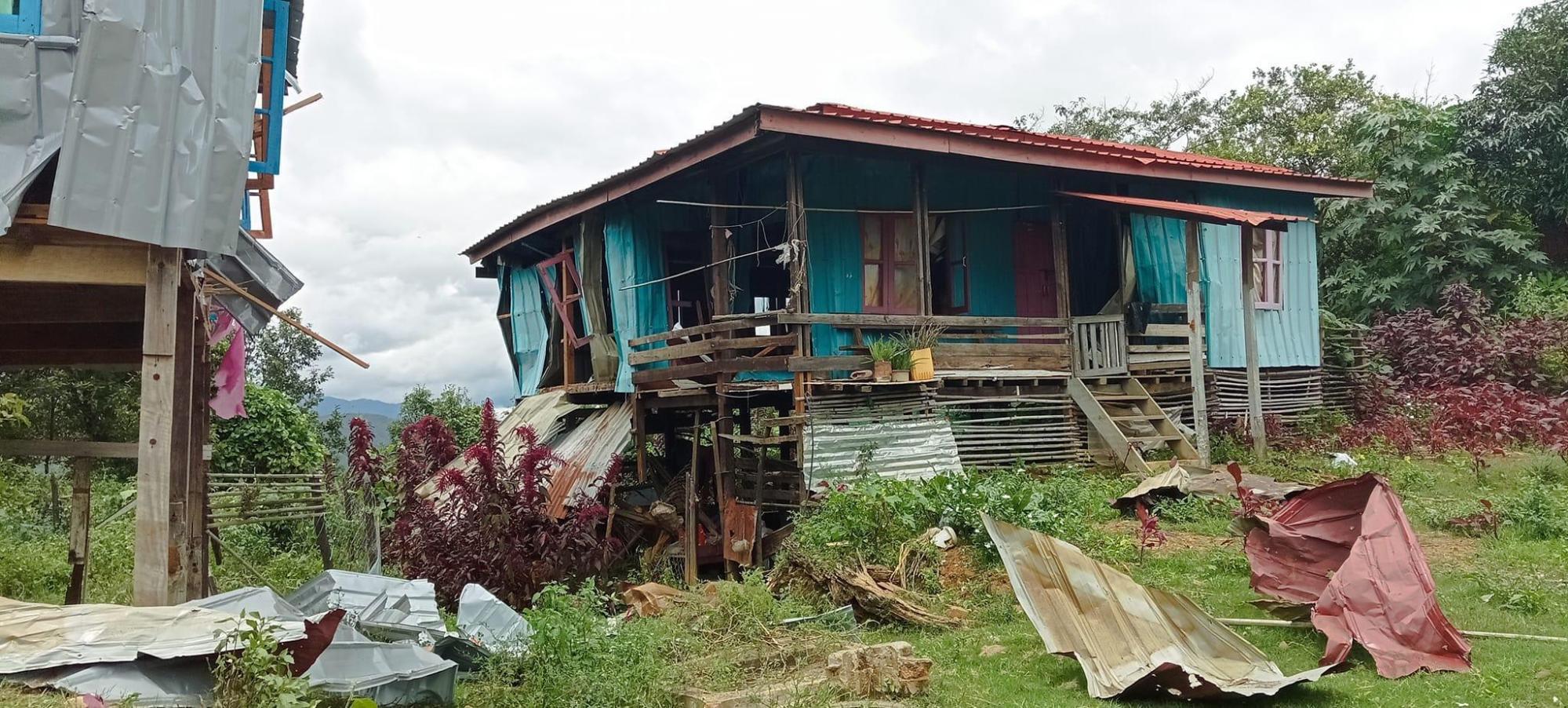
Figure 36: UGC showing damage to a residential building in Khuafo, geolocated by Mynmar Witness [22.752099, 93.425127] (source: Khit Thit Media).
Conclusion
Physical damage to church buildings has emerged as a prominent impact of the conflict in Chin state. Through a mixed methods approach, this investigation has helped to shine further light on the conflict’s evolving dynamics. ACLED data alongside case studies investigated by Myanmar Witness indicates that use of airstrikes has significantly increased since 2022, which is reflected in the nature of the damage sustained by churches in Chin state.
Though attribution has not been fully established, this report has analysed UGC, showing damage consistent with the use of aircraft ordnance. Since the MAF maintains overwhelming air superiority across Myanmar, it is highly likely that the Myanmar military was responsible for the alleged airstrikes.
Areas of known resistance, such as the townships placed under martial law, have experienced a concentration of reported attacks. While the extent of the impact on places of worship across Myanmar remains unknown, the conflict is having a sustained and long-term impact on the Christian population of Chin state.
Myanmar Witness will continue to monitor, identify, verify, analyse and report on the events that impact religious buildings and other facilities across Myanmar, so that the responsible parties are held to account. Myanmar Witness seeks to shed light on atrocities and focuses on the effects on civilian’s daily lives and safety.
List of abbreviations
Armed Conflict Location & Event Data – ACLED
Chinland Defence Force – CDF
Chin National Army – CNA
Chin National Defence Force – CNDF
Fire Information for Resource Management System – FIRMS
International Committee of the Red Cross – ICRC
International Humanitarian Law – IHL
Light Infantry Division – LID
Myanmar Air Force – MAF
Myanmar Information Management Unit – MIMU
National Unity Government – NUG
Quantum Geographic Information System – QGIS
State Administration Council – SAC
User Generated Content – UGC


