Key Event Details
Location of Incident: Multiple villages in Sagaing Township (စစ်ကိုင်းမြို့နယ်), Sagaing Region (စစ်ကိုင်းတိုင်းဒေသကြီး):
TheInn Sa Village (အင်းစရွာ) [22.118200, 95.694976]
Taung Kyar Village (တောင်ကြားရွာ) [22.099079, 95.705261]
Mu Thar Village (မူးသာရွာ) [22.106790, 95.658927]
Ma Gyi Kone Village (မကျီးကုန်းရွာ) [22.108310, 95.665611]
Taung Myo Village (တောင်မြို့ရွာ) [22.080650, 95.667137]
Ywar Htaung Village (ရွာထောင်ရွာ) [22.065469, 95.646293]
Ywar Thit Village (ရွာသစ်ရွာ) [22.068687, 95.656561]
Ta Pa Yin Kwe Village (တပုရင်းကွဲရွာ) [22.049150, 95.669937]
Date/Time of Incident:
20 – 24 April 2023
Alleged Perpetrator(s) and/or Involvement:
Light Infantry Division (LID) 99
People’s Defence Forces (PDF)
Summary of Investigation:
It is alleged that the Myanmar military’s LID 99 set fire to eight villages, causing the mass displacement of residents, following PDF activity in the area.
Myanmar Witness verified (to varying levels) six of the eight fires through NASA’s Fire Information for Resource Management System (FIRMS), satellite imagery analysis and analysis of user-generated content (UGC). They occurred in villages in close proximity to one another between 20-25 April 2023.
Fires in Inn Sa and Ta Pa Yin Kwe villages were verified using FIRMS, Sentinel and UGC.
Fires in Mu Thar and Taung Kyar villages allegedly destroyed 400 houses. Myanmar Witness assessed Sentinel imagery and believes that fires occurred between 20-25 April 2023.
While no UGC could be geolocated of the remaining villages, FIRMS registered fire data in Ywar Thit on 23 April 2023, and Sentinel data reveals fire damage in Taung Myo and Ywar Htaung villages between 20-25 April.
The fires in Ma Gyi Kone (မကျီးကုန်းရွာ) and Taung Kyar could not be verified due to a lack of UGC, FIRMS data or satellite imagery.
Following these events, reports of mass displacement and a graphic beheading surfaced online. Myanmar Witness will continue to search for verifiable information.
Summary
On 20 April 2023, a column of around 100 military personnel entered Sagaing through Myinmu Township (မြင်းမူမြို့နယ်), according to Mandalay Free Press. Eight villages were allegedly set on fire between 20 – 24 April 2023 according to multiple media sources, reportedly causing mass displacement and the destruction of civilian infrastructure.
According to Khit Thit, the systematic burning of villages by the military was retaliation for a People Defense Force (PDF) attack in Kywei Pon (ကြွယ်ပုံ) — an alleged Pyu Saw Htee aligned village — on 13 April 2023. The unnamed PDF group allegedly attacked the military’s Thingyan festival in Kywei Pon with a drone. According to a report by the Security Administration Council (SAC), eight people, including five children, were killed and 30 others were injured in the attack. Myanmar Witness has been unable to verify these claims.
Myanmar Witness verified six of the eight fires through FIRMS, satellite imagery analysis and analysis of user-generated content (UGC). They occurred in villages in close proximity to one another between 20-25 April 2023. For example, Myanmar Witness geolocated UGC of the destruction of civilian infrastructure in Inn Sa (အင်းစ) and Ta Pa Yin Kwe (တပုရင်းကွဲရွာ) and chronolocated the UGC to within the time period investigated.
It is claimed that another two villages, Mu Thar (မူးသာ) and Taung Kyar (တောင်ကြား), were set on fire on 21 April 2023, resulting in the destruction of 400 houses. By analysing the visible changes to the ground on Sentinel imagery, Myanmar Witness believes that it is likely that fires occurred between 20-25 April 2023.
While no UGC could be geolocated of the remaining villages, FIRMS registered fire data in Ywar Thit (ရွာသစ်ရွာ) on 23 April 2023, and Sentinel data indicates fire damage in Taung Myo (တောင်မြို့ရွာ) and Ywar Htaung (ရွာထောင်ရွာ) between 20-25 April. The fires in Ma Gyi Kone (မကျီးကုန်းရွာ) and Taung Kyar could not be verified due to a lack of UGC, FIRMS data or satellite imagery.
Social media claims related to these fires, the displacement of civilians, and troop movements places responsibility for the fires and destruction with the Myanmar military. Myanmar Witness has collected these claims; however, has been unable to verify them. The fires occurred in villages in close proximity to one another, in an area where there was alleged PDF activity. Myanmar Witness continues to monitor information related to these events to build a picture for accountability.
Myanmar Witness has been able to verify the following:
Fire in Inn Sa. Geolocation of images of fire-damaged structures, including a monastery, which were likely taken on 21 April 2023. FIRMS and Sentinel data corroborates that Inn Sa was on fire on 21 April 2023.
Fire in Ta Pa Yin Kwe. Geolocation of UGC showing burn damage to structures. FIRMS data indicates the fire damage occurred on 23 April 2023.
Fire in Ywar Thit. FIRMS data indicates fires on 23 April 2023.
Loss of vegetation consistent with fire damage in six of eight villages. Sentinel imagery shows a loss of vegetation, allegedly burned by the military, between 20 April 2023 and 25 April 2023.
The investigation walkthrough
Myanmar Witness has identified UGC, FIRMS data and satellite imagery which has allowed the verification of six out of eight reported fires. Additionally, Myanmar Witness has identified claims related to Myanmar military troop movements which could signal attribution for these fires; however, Myanmar Witness has been unable to verify these claims at present. The following map provides an overview of the investigated events.
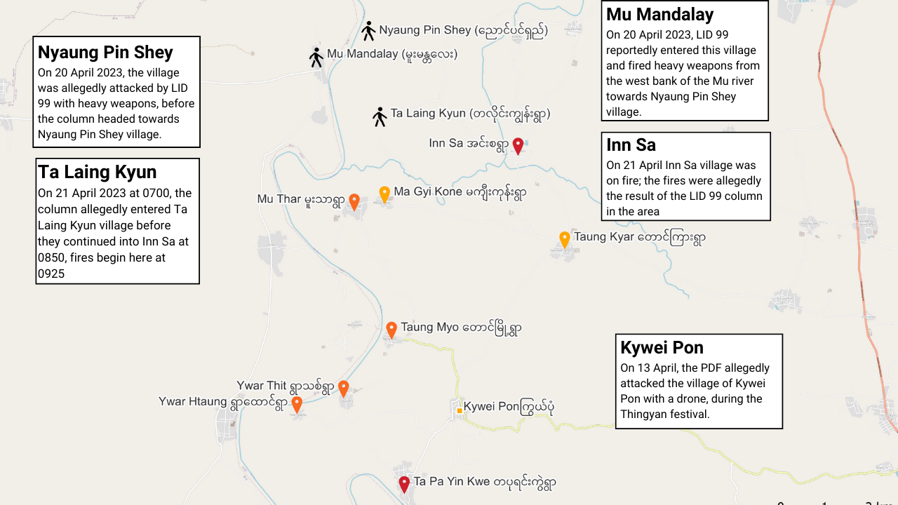
Figure 1: Map of the locations where Myanmar military troops were reportedly seen (black pins) and the eight villages where fires were reported. The fires Myanmar Witness verified during this investigation are marked with red pins, the partially verified fires are marked with orange pins and the two fires that were not verified are marked with yellow pins (map created by Myanmar Witness using QGIS).
Inn Sa village (verified)
Myanmar Witness geolocated footage of Htu Par Yone Monastery, as well as other parts of Inn Sa, having been destroyed or suffering heavy burning damage at around [22.120529, 95.695671] (Figure 2). Myanmar Witness has verified that the fire damage occurred on 21 April 2023, through the use of FIRMS registering a fire in the location on 21 April 2023 and Sentinel showing damage to the area between 20-25 April 2023.
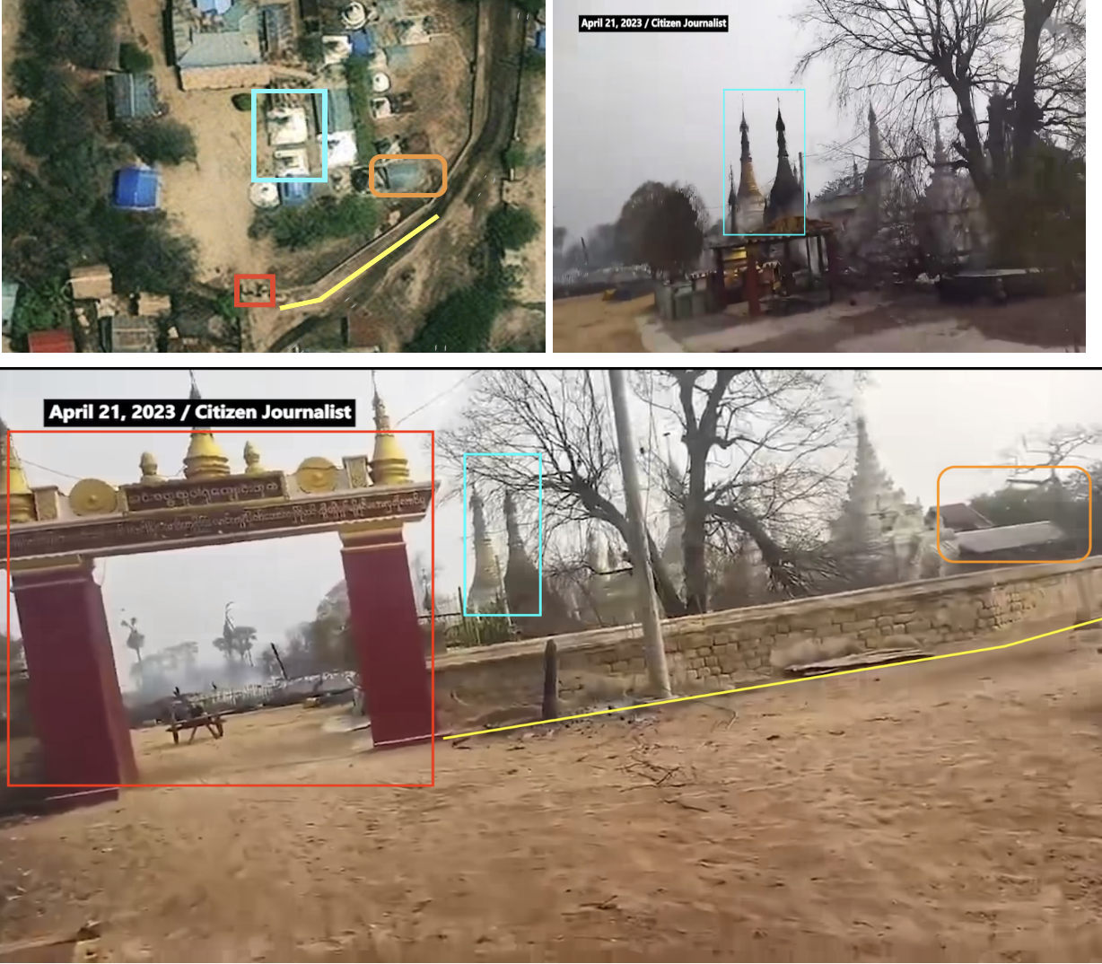
Figure 2: Geolocation of fire damage in Inn Sa at around [22.120529, 95.695671] (source: RFA).
Sentinel satellite imagery shows hugely decreased definition and significant discolouration in an area of Inn Sa between 20 and 25 April 2023 (Figure 4). These changes are likely a result of fires affecting structures, the ground, and foliage in the area. This hugely affected area aligns with the burn damage affected area from Figure 2, geolocated to Inn Sa around [22.120529, 95.695671] allegedly on 21 April 2023. Myanmar Witness used inverted colour in the following examples, as a way to analyse the changes in the ground more clearly.
FIRMS fire data registers a fire in this village on 21 April 2023, in-line with reports that the village was attacked on 21 April 2023 (Figure 4).

Figure 3: Inn Sa with discolouration in large areas of the village – likely as a result of fire (source: Sentinel).
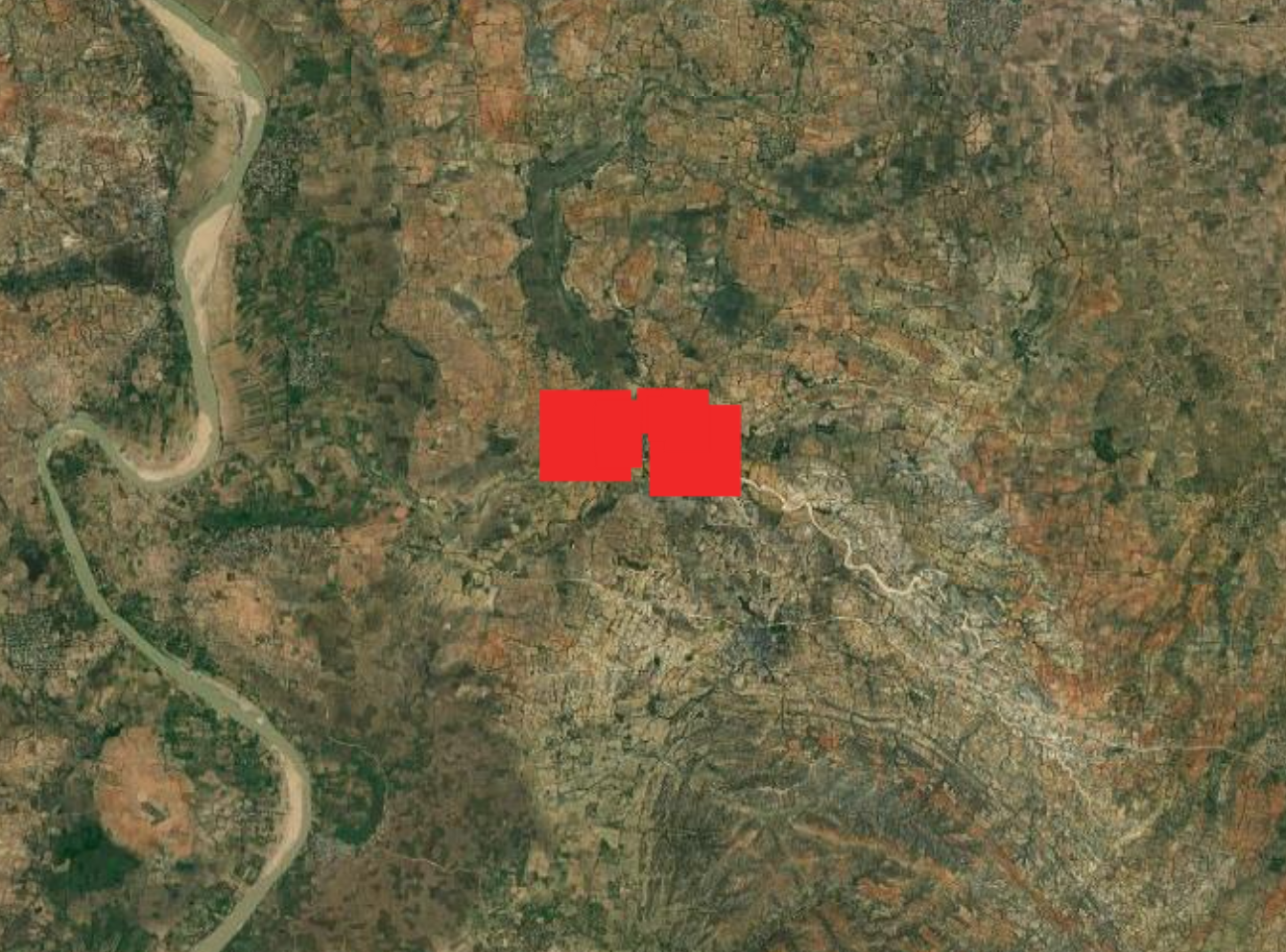
Figure 4: Inn Sa village registered fires on 21 April 2023 (source: FIRMS).
Ta Pa Yin Kwe village (verified)
Myanmar Witness geolocated footage of damaged structures in Ta Pa Yin Kwe, allegedly taken on 23 April 2023, including structures that appear to have sustained fire damage near the pagodas (Figure 5).
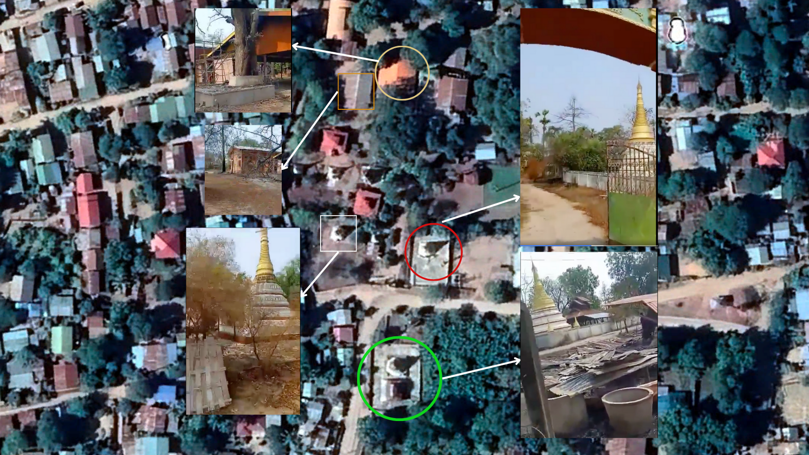
Figure 5: Geolocation of footage from 4.11s of Ta Pa Yin Kwe at around [22.052194, 95.670174] (source: redacted due to privacy concerns).
Sentinel satellite imagery of Ta Pa Yin Kwe village shows a discolouration of the ground between 20 – 25 April 2023 (Figure 6, 7 and 8) which is consistent with fire damage. Additionally, FIRMS registered a fire in the village on 23 April 2023, narrowing down the time window when the events took place. This supports the claims that fires in these villages occurred on 23 April 2023 and caused damage to the villages. The fires were allegedly the result of the Myanmar military; however, Myanmar Witness has been unable to verify these claims.
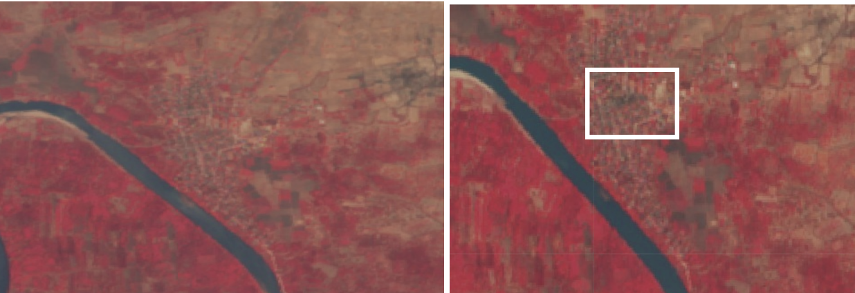
Figure 6: Ta Pa Yin Kwe, showing some areas of the village affected by ground changes – likely as a result of fire (source: Sentinel).
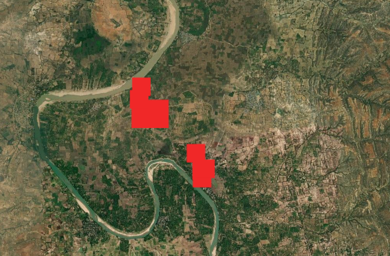
Figure 7: Ta Pa Yin Kwe and Ywar Thit registering heat signatures on FIRMS on 23 April 2023 (source: FIRMS).
Ywar Thit village (verified)
Sentinel imagery in Ywar Thit – a village that also experienced fire on 23 April 2023 according to FIRMS data (as seen above in Figure 7) – can be seen to have experienced a similar discolouration to that seen in Ta Pa Yin Kwe village between 20 – 25 April 2023 (Figure 8).
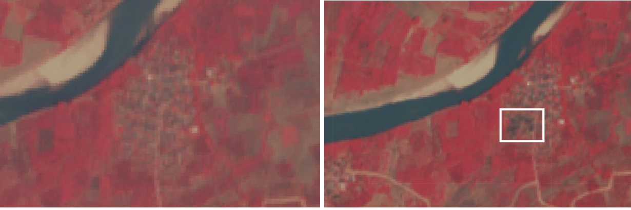
Figure 8: Ywar Thit, showing southern and central areas of the village affected by ground changes – likely as a result of fire (source: Sentinel).
Mu Thar, Taung Myo, and Ywar Htaung villages (partially verified)
Sentinel satellite imagery also shows decreased definition and discoloration in Mu Thar, Taung Myo and Ywar Htaung villages between 20-25 April 2023, also likely a result of fire damage (Figure 9, 10 and 11). It is alleged these villages were set on fire on 21 April and 22 April respectively. This is supported by the sentinel imagery which narrows down the timeframe for the events to between 20-25 April; however, Myanmar Witness cannot confirm a more specific date with geolocation or chronolocation, due to a lack of UGC or FIRMS data.

Figure 9: Mu Thar with central areas of the village affected by ground changes – likely as a result of fire (source: Sentinel).
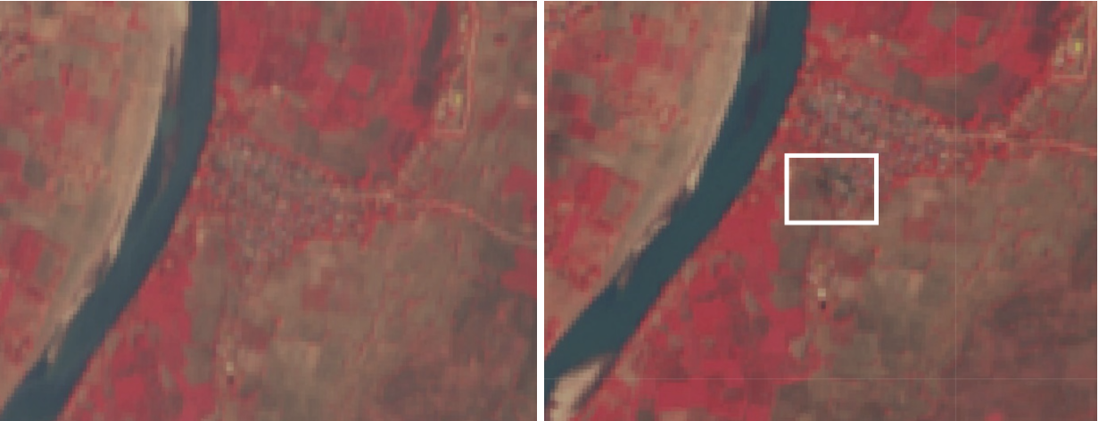
Figure 10: Taung Myo with central areas of the village affected by ground changes – likely as a result of fire (source: Sentinel).
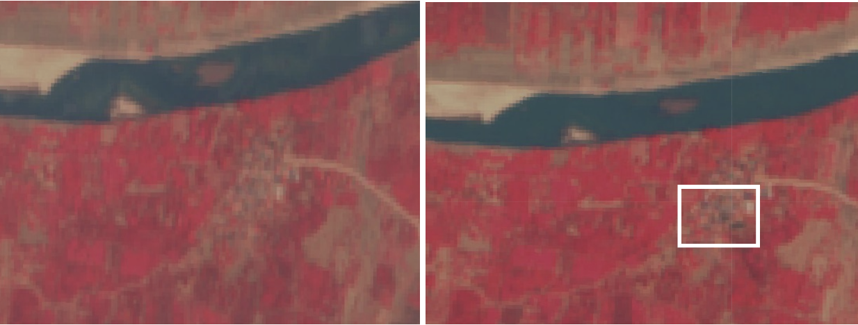
Figure 11: Ywar Htaung with some areas of the village affected by ground changes – likely as a result of fire (source: Sentinel).
Displacement and beheading
According to media sources, the fires and alleged presence of Myanmar military troops in Sagaing township has reportedly displaced tens of thousands of people in the area. For example, Khit Thit Media shared images showing groups of people, including women and children, leaving specifically Inn Sa and Taung Kyar village in Shwegu township. The anti-military media organisation Myaelatt Athan, reported that over 30,000 people from seven of the eight villages discussed in this report (Inn Sa, Ta Pa Yin Kwe, Ywar Htaung, Ywar Thit, Taung Myo, Mu Thar, Taung Kyar) were displaced between 20 and 24 April 2023.
Myaelatt Athan also reported claims by a local from Ywar Thit that a total of six villagers were taken hostage by military troops, two of whom were later released, prior to the media report airing. Similar claims were made by RFA Burmese, which reported that three villagers were taken hostage in Inn Sa on 21 April 2023. Myanmar Witness cannot confirm that individuals were taken hostage, however, the claims are consistent with other reports of military presence in the area around the time of the fires.
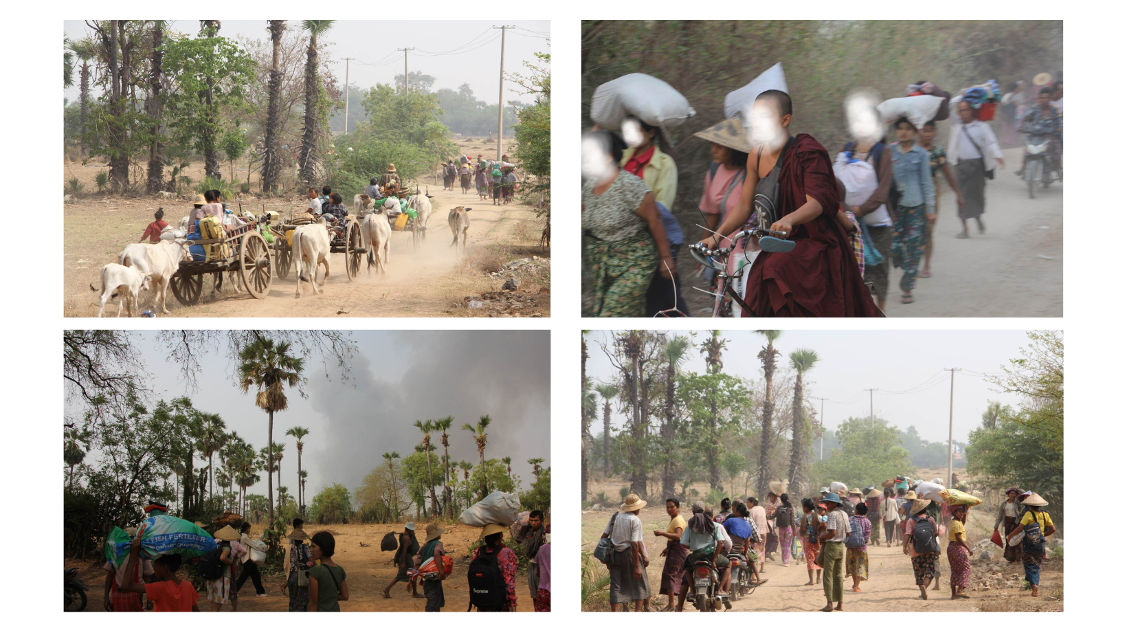
Figure 12: Unverified images alleged to be IDPs escaping from Inn Sa and Taung Kyar (source: Khit Thit Media).
Mandalay Free Press reported that on 23 April 2023, at the same time as Ta Pa Yin Kwe was on fire, a column of LID 99 soldiers arrested and tortured a local man from Ta Pa Yin Kwe. His body was later found, beheaded (Figure 13). The available UGC does not provide enough information for Myanmar Witness to confidently verify whether the beheading took place in this location; however, Myanmar Witness has been monitoring claims of multiple beheadings in Sagaing and the surrounding areas, also allegedly carried out by the LID 99. For example, see the report: ‘Tortured, beheaded and dismembered: A series of violent events in Sagaing’.
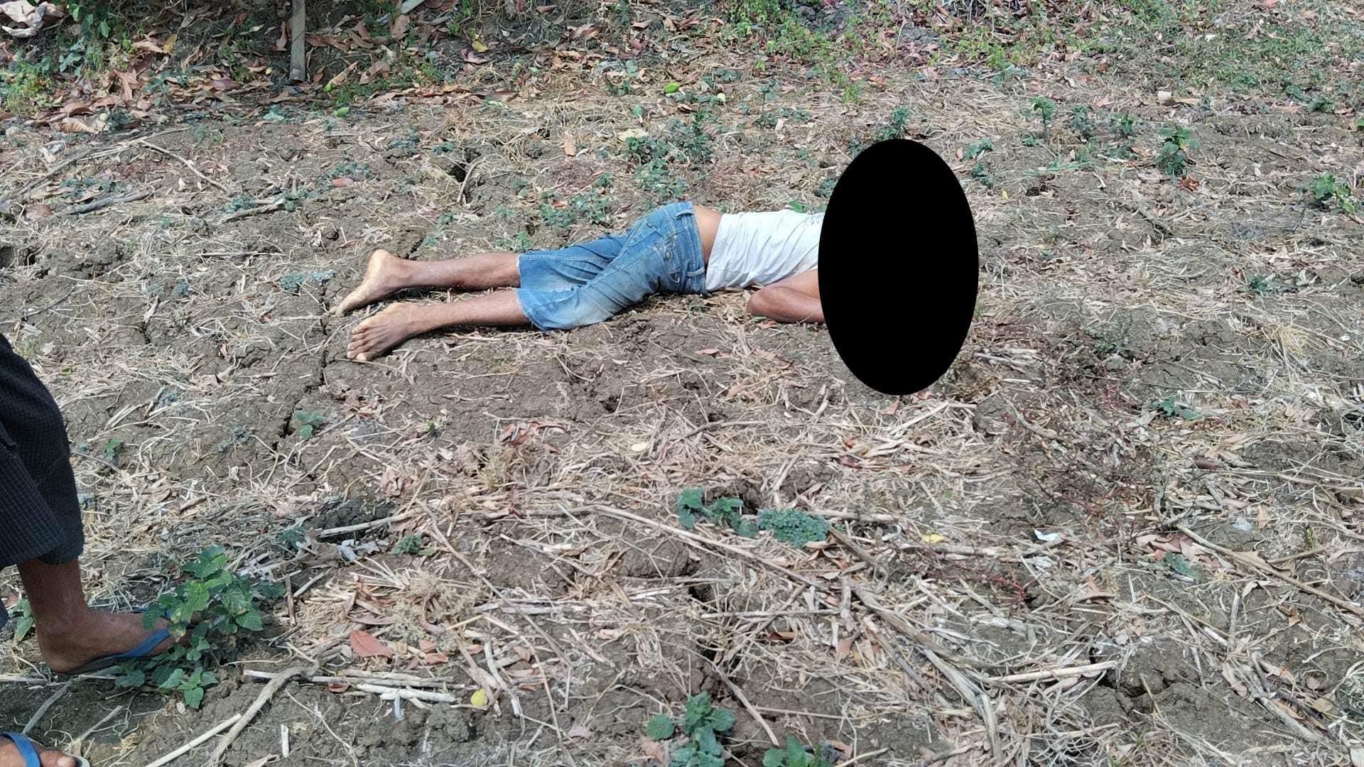
Figure 13: An image allegedly of a local man beheaded by the military in Ta Pa Yin Kwe. (Source: Mandalay Free Press).
Attribution
Myanmar Witness has identified and analysed eyewitness testimony reported by local news media or by social media users which claimed the military were responsible for the fires in these villages, or placed the military in the vicinity. However, Myanmar Witness was unable to verify the claims related to troop movements or specific units (claims which are presented in the following section).
Although Myanmar Witness was unable to fully verify which actors were responsible for the fires in the area due to a lack of UGC showing the fires being set, this type of activity, including the sequential nature of fires, matches that reported on by Myanmar Witness in other parts of Sagaing and the surrounding regions. In other locations, Myanmar Witness has analysed footage showing military intent to burn villages, and has identified clear patterns of the use of fire by military units across the region. For more information, see Myanmar Witness’ reports on fires.
Reported Troop Movements
On 20 April 2023, a local scout channel claimed that, at around 2000 local time, a military column made up of the LID 99 — which is also known as the ‘Ogre Column’ for their violence — entered Mu Mandalay (မူးမန္တလေး) village in Myinmu township and fired heavy weapons from the west bank of the Mu river towards Nyaung Pin Shay village (ညောင်ပင်ရှည်), Sagaing township. As a result, villagers were reportedly forced to flee to safer places.
At 2100 local time, the scout channel stated that the military column left Mu Mandalay and headed towards Nyang Pin Shay. At 0700 the following day, the column allegedly entered Ta Laing Kyun village (တလိုင်းကျွန်းရွာ) before continuing to Inn Sa at 0850, where they began to set buildings on fire at around 0925. Myanmar Witness has verified that fires took place in the village on this day (see above).
BBC Burmese reported that Myanmar military troops destroyed 10 houses in the village of Taung Kyar – adjacent to Inn Sa – on 23 April 2023. BBC Burmese also stated that it is the fourth time that Taung Kyar has been affected by fires set by the military since the coup. However, Myanmar Witness has been unable to verify these claims using satellite imagery or analysis of UGC.
It’s alleged the column consisted of around 100 troops that then divided into two columns which entered Mu Thar and Ma Gyi Kone simultaneously on 22 April 2023 (source redacted due to privacy concerns). While Myanmar Witness wasn’t able to verify reports about troops movement, evidence that fires took place in Mu Thar was visible on satellite imagery between 20 – 25 April (as outlined above).
In the following days, a further 16 houses in Taung Myo, 37 houses in Ywar Thit, 5 houses in Ywar Htaung, and 53 houses from Ta Pa Yin Kwe were allegedly destroyed by these two columns (source redacted due to privacy concerns). Myanmar Witness was able to verify differences to the terrain in these villages between 20-25 April 2023 (as outlined above).
Future monitoring
Fires and ground fighting which impact civilians have become more commonly reported on by civilian journalists in recent months. The result is the destruction of homes, communities and mass internal displacement. Since the coup in 2021, more than 1,300,000 people have fled their homes, according to the ISP Myanmar research group.
It is essential to continue monitoring the clashes between parties to the conflict, given claims that these clashes are impacting civilian infrastructure, causing displacement, and, in some cases, causing deaths. This is particularly important in the ‘dry zone’ — Sagaing, Chin and parts of Magway — which are areas of strategic importance for both sides of the conflict.
Myanmar Witness will continue to monitor UGC, satellite imagery, scouting channels, and other related information to identify any evidence of human rights abuses and aggressive military tactics, which can provide an insight into the patterns of conflict.
Abbreviations
Fire Information for Resource Management System – FIRMS
Internally Displaced People – IDP
Light Infantry Division – LID
People Defense Forces – PDF
State Administration Council – SAC
User Generated Content – UGC


