The Russia-Ukraine Monitor Map is a crowdsourced effort by Centre for Information Resilience (CIR) and the wider open source community to map, document and verify significant incidents during the conflict in Ukraine.
Its aim is to provide reliable information for policymakers, journalists, and justice and accountability bodies about the evolving situations both on-the-ground and online. Bellingcat, Mnemonic and the Conflict Intelligence Team have also begun to contribute to the map in recent days.
Benjamin Strick, Director of Investigations at CIR, explained:
“At CIR, we chose to begin mapping out verified incidents surrounding the build-up of Russian troops, and later the beginning of the conflict in Ukraine, so that everyone could have access to reliable, accurate information about what is going on and to boost the integrity of the information environment. Before any content makes its way onto the map, it is further reviewed by senior investigators at the CIR to ensure the information is accurate and safe.”
“A first look at the map shows there are a lot of pins. Each one represents an incident or event depicted through video, photo, or commercial satellite imagery and has undergone a rigorous verification process to identify where and when it was taken.”
“The verification work is carried out by open source investigators as well as the wider community through geolocationand chronolocation. Once collected from social media, the content is logged in a central database where the material is archived for future use by researchers, reporters as well as justice and accountability bodies.”
He added:
“Each piece of information that you see on the map is checked for its content and given a brief description so that keywords can be searched to look for specific trends, patterns, or to dive into the verified data.”
The map is publicly viewable on both desktop and mobile and as of February 27 has had almost 900,000 views and more than 860 items logged to give an accurate up to date detailed view of what is happening in Ukraine. The map can be viewed here:
https://maphub.net/Cen4infoRes/russian-ukraine-monitor
Ross Burley, Co-Founder and Executive Director of CIR said:
“The Kremlin has a track record of weaponising and distorting information. That’s why its essential to use open source methods to bring clarity, accountability and truth to reporting around the conflict. We are proud that the open source community has come together to verify and record incidents.
NOTES
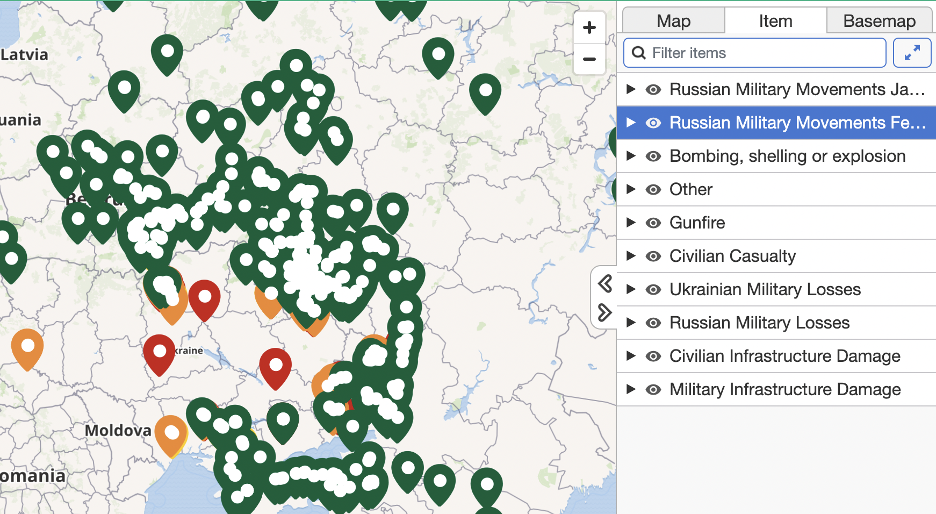
How to use the map
There are different coloured pins on the map. This is to isolate specific categories of footage. On the right of the map, this list of categories can be found. Each of these is assigned a colour class. It must be noted that the categories may change as the conflict in Ukraine develops.
At time of writing, the pins on the map are allocated to categories such as Russian military Movements, bombings, civilian casualties, military losses, infrastructure damage and gunfire.
The pins are sorted by date of publication of footage or chronolocation. In some instances, footage may be published days after the actual incident. This is due to our investigations taking the time to be as accurate as possible.
The map is also searchable using the ‘filter items’ box above the categories.
This allows for searches of dates, specific weapon systems, if there are vehicles with descriptors such as the letter ‘Z’ (as has been detailed in numerous media reports) or in specific areas.
A more refined view can also be made by clicking on the visibility icon of the categories to isolate pins and show only pins from one category.
There is already a significant amount of information on the map for viewers to explore and it will continue to be updated in the days and weeks ahead.
For further information about our work, please email [email protected]