By Benjamin den Braber and Benjamin Pittet
Introduction
The Eyes on Russia project is an open source investigations project to map, document, and verify significant incidents during the conflict in Ukraine. Our work aims to provide reliable information to the world. The lead resource of the Eyes on Russia project is our Russia-Ukraine Monitor Map. This investigation is a result of that work.
The verification seen in this report will be logged in a central database where the material is archived for future use by researchers, reporters as well as justice and accountability bodies.
On March 29, Russia’s Ministry of Defence announced the withdrawal of its forces from Kyiv and Chernihiv regions. As the military left, stories, images and videos of horror emerged, showing what happened during Russia’s brief occupation of those areas. Some leaders have described what has emerged as evidence of possible war crimes.
This report examines the available open source evidence to piece together a string of cases where at least 18 people were killed along highways leading into Ukraine’s capital, Kyiv.
The areas we looked at pass through towns such as Buzov, Myla, Vorzel and Bucha; towns now synonymous with extrajudicial killings, rape, and mass graves during their occupation.
The details of the cases are grim. In six events documented by our team, we have found at least five casualties along the E373 Highway, and 13 casualties along the E40 Highway.
This report details those cases and looks at visual clues available to open source investigators to identify what happened, where it happened, when it happened and, ultimately, who was responsible.
It is highly likely that Russian forces were responsible for the civilian harm incidents we have documented. In each case, Russian military forces were in control of or close by to each location.
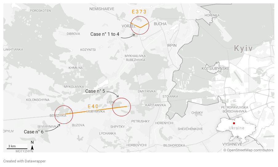
Figure 1: Overview of location of cases near Kyiv, on the E40 & E373 highways
Analysis of open source material – Bucha & Vorzel [E373]
Following the publication of photos and videos showing civilian victims on social networks, the Eyes on Russia team started to investigate the killings committed in the cities of Bucha, Irpin, Hostomel, and Vorzel.
This case specifically focuses on the five visually confirmed casualties on a stretch of the E373 highway between Vorzel and Bucha.
● Case 1 – Bucha [E373]: Decapitated women in vehicle
● Case 2 – Vorzel [E373]: Deceased civilian next to vehicle
● Case 3 – Vorzel [E373]: Two deceased men at Russian roadblock
● Case 4 – Vorzel [E373]: Burned corpse close to Russian roadblock
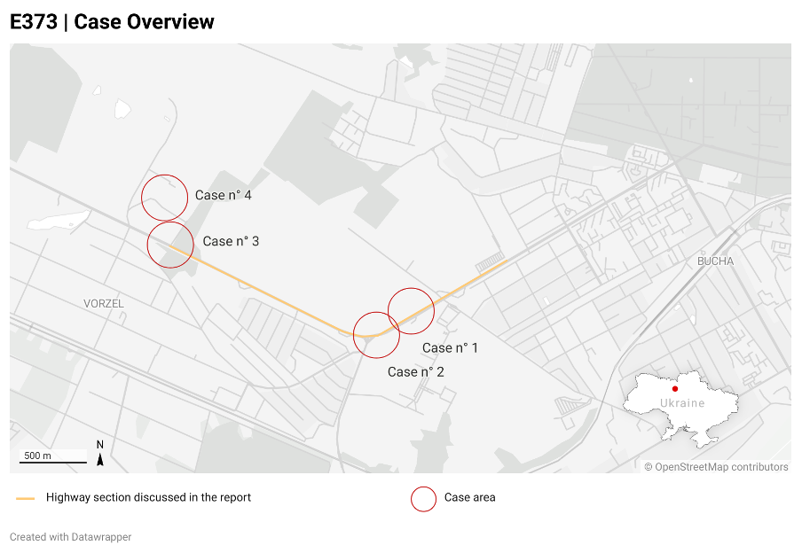
Figure 2: Location of cases on Highway E373
Case 1 – Bucha [E373]: Decapitated women in vehicle
On April 3, Ukrainian politician Oleksiy Goncharenko posted a video on his Twitter account showing a dead person in a car. Goncharenko states in the tweet that the video was filmed in Bucha. We were able to geolocate the video.
The car and the deceased person are on the E373 highway leaving the city of Bucha.
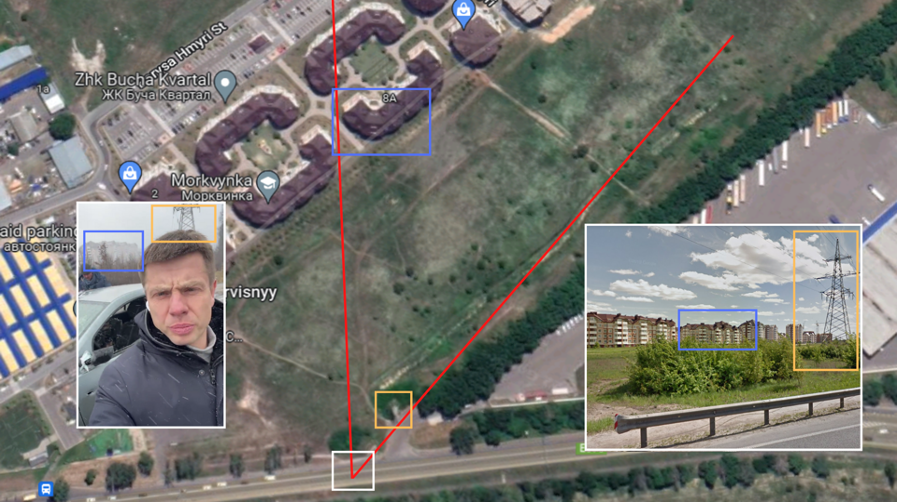
Figure 3: Geolocation of decapitated women in vehicle.
The orientation of the car indicates that it was most likely travelling in the direction of Bucha. Several impacts to the front of the car are visible in the video.
Around the impacts, the body and windshield of the car are bent inward, indicating that the shots were coming from the front of the car. The overall damage to the car is not significant enough to be consistent with 30mm rounds. The impacts appear more consistent with heavy machine gunfire.
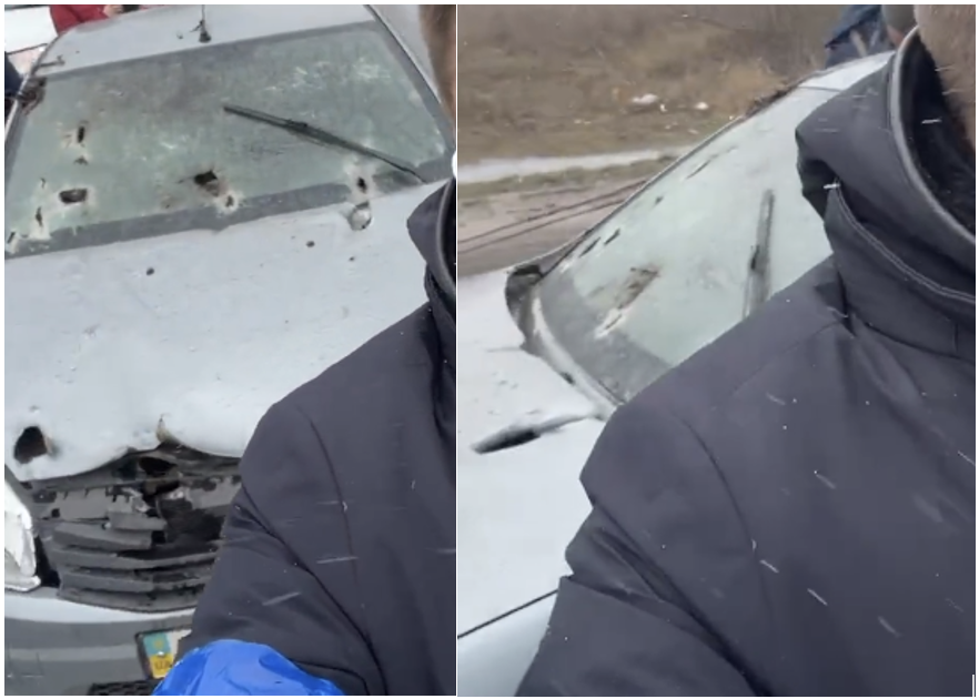
Figure 4: Photo showing damage to car in which victim was found
On March 11, in a Planet satellite image, a military vehicle was visible in the direction from which the shots were fired, 790 meters from the civilian vehicle [Location]. The dimensions of the vehicle correspond to those of an armoured combat vehicle.
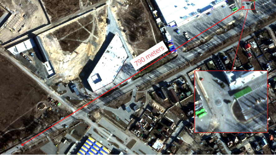
Figure 5 (above): Military vehicle visible on satellite imagery in proximity to civilian casualties. Image © 2022 Planet
The military vehicle arrived in the area between February 28 and March 11. The military vehicle was no longer visible in the images of March 29. According to the information available to the Eyes on Russia team, Russian forces were controlling the area at that time.
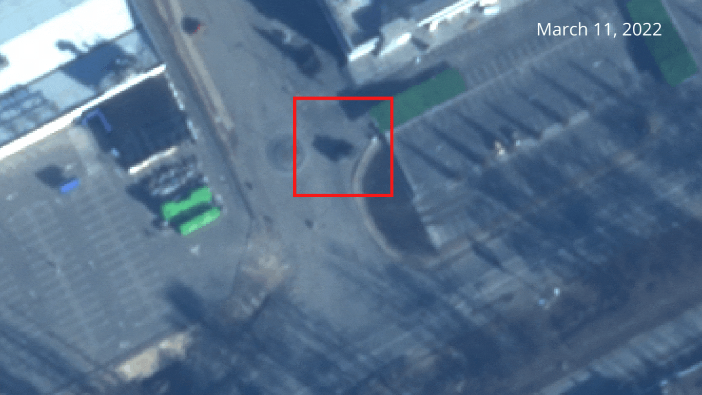
Figure 6: Satellite imagery of Bucha | Image 1 © 2022 Planet, Image 2 : Maxar products. Worldview © 2022 Maxar technologies. Graphic only viewable on the website version of this report.
The civilian vehicle appears for the first time on satellite images between February 28 and March 11.
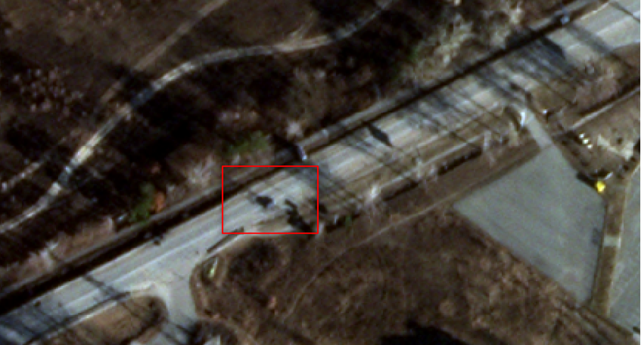
Figure 7: Satellite imagery of Vorzel | Image © 2022 Planet
Case 2 – Vorzel [E373]: Deceased civilian
Three hundred meters away on the same road, a body was photographed lying on the side of the road next to an overturned vehicle [location]. The photo was posted on the Twitter account of the advisor of the Ukrainian president, Mykhaïlo Podoliak.
The overturned vehicle appears for the first time on Airbus satellite imagery of March 29.
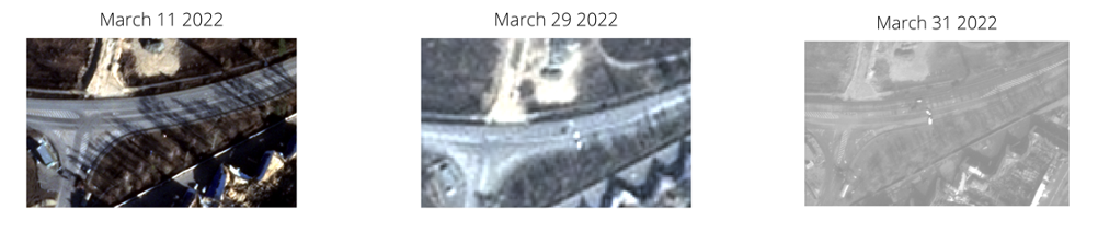
Figure 9: Satellite imagery of Vorzel | Image 1 & 2 © 2022 Planet, Image 3 : Maxar products. Worldview © 2022 Maxar technologies
Case 3 – Vorzel [E373]: Two deceased men at Russian roadblock
Civilians were also targeted at an intersection on the same highway in an industrial area of the village of Vorzel. On April 6, Ukrainian blogger Denys Kazanskyi posted images of three deceased people.
The OSINT community on Twitter geolocated the bodies. The Eyes on Russia team was able to review and confirm the location of the bodies. The bodies are about 1.5 kilometres from the cases discussed above.
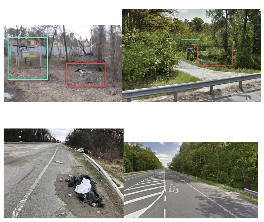
Figure 10: Geolocation of two corpses next to Russian roadblock.
Case 4 – Vorzel [E373]: Burned corpse close to Russian roadblock
The last photo posted by the Ukrainian blogger shows a burned body. Thanks to another video from the same location, the body was geolocated to the warehouse next to the intersection seen above.
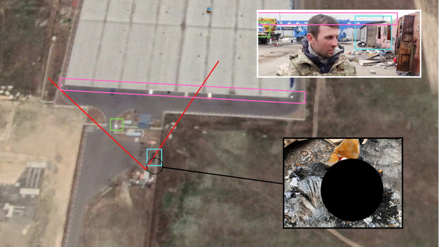
Figure 11: Geolocation of video showing burned corpse.
In addition to the four cases mentioned above, a video released on April 4 shows that this stretch of highway was the scene of additional violence during this period. Civilian infrastructure and several vehicles were damaged.
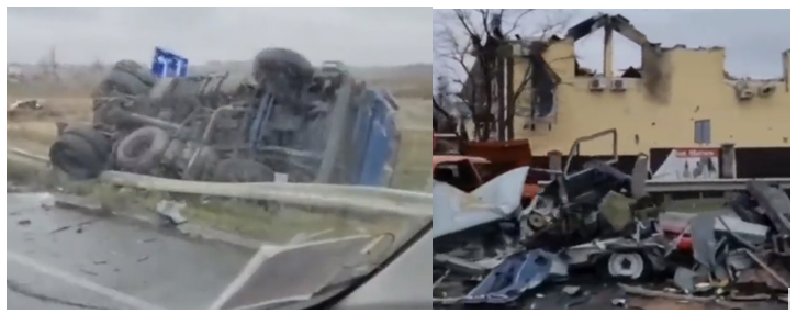
Figure 12: Destroyed civilian infrastructure and vehicles around the E373 highway.
The team relied in particular on a video published on March 4 filmed with a drone. The intersection of interest in Case 2 is visible in the Drone footage from 0:00-0-11 during which, similar to the above Satellite imagery of March 11, no damaged vehicles could be seen at the E373 intersection.
We can thus conclude the damage and civilian casualties occurred after March 11.
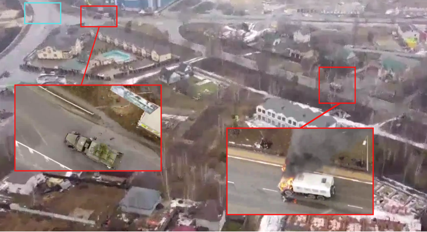
Figure 13: Russian forces in Vorzel seen on drone footage published on March 4 2022.
The drone footage also shows a Russian checkpoint at the intersection of Case 3. Equipment can also be seen in the storage area to the right of the image. Russian vehicles located between the intersection of cases 2 and 3 are also observed in the video.
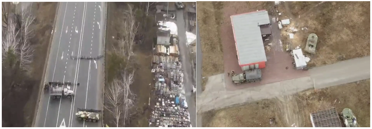
Figure 14: Russian forces in Vorzel seen on drone footage published on March 4 2022.
The Eyes on Russia team mapped Russian military presence around the civilian casualties on the E373 highway.
The map below shows the civilians killed in this specific area during the period when the towns of Bucha and Vorzel were contested or controlled by Russian forces.
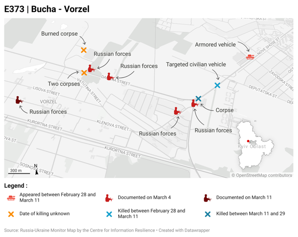
Figure 15: Overview of bodies around the E373 highway between Bucha and Vorzel and exact location of Russian forces seen in Drone footage:
Russian checkpoint (04/03/2022) : 50.549556, 30.163872
Russian special forces (11/03/2022) : 50.546308, 30.151128
Russian vehicles (04/03/2022) : 50.548588, 30.168254
Russian truck (04/03/2022) : 50.541745, 30.181313
Russian truck (04/03/2022) : 50.542945, 30.184541
Russian column (04/03/2022) : 50.532350, 30.193426
Russian column (15/03/2022) : 50.550839, 30.205575
Military vehicle (11/03/2022) : 50.548869, 30.199159
Analysis of open source material – Myla & Buzov [E40]
Following the publication of drone footage showing a civilian being shot by Russian soldiers, the Eyes on Russia team started to investigate a total of 13 visually confirmed casualties along the E40 highway, between Buzov and Myla, west of Kyiv.
● Case 5 – Myla [E40]: 11 people shot around gas stations including at least 7 civilians, next to a Russian camp.
● Case 6 – Buzov [E40]: Two deceased men excavated from grave behind gas station, next to Russian camp.
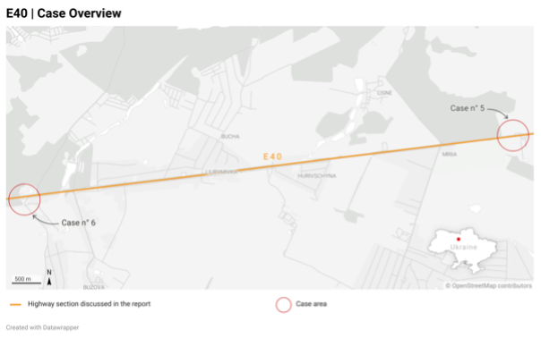
Figure 16: Overview of locations on the E40 near Kyiv of cases
Case 5 – Myla [E40]: 11 people shot around gas stations including at least 7 civilians, next to a Russian camp
On March 15, Drone footage was published by German News magazine ‘frontal’ depicting the March 7 targeted shooting at civilians on the E40 highway.
The male who is visibly shot is dragged into the bushes by Russian soldiers. In later footage, depicting the same area after it was re-taken by Ukrainian forces, the same man is seen burned, next to his vehicle, indicating the body has been moved before being set on fire.
After investigation, the Eyes on Russia team was able to geolocate the footage to a gas station just outside the town of Myla, Kyiv Oblast.
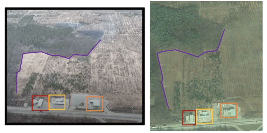
Figure 17: Geolocation of drone footage showing 2 civilians shot in and around their vehicle.
On April 2, the Russian forces had withdrawn from the area after the Russian MoD announced it would scale down operations around Kyiv to focus on battles in the east.
Several images appeared online of the area at which the drone footage had been shot. Several more bodies are visible in the images, indicating that in the days after the drone footage was shot, multiple more people were killed on the same stretch of road.
Further drone footage published on YouTube shows a Russian military camp behind the gas station and several burned out vehicles on the highway. At 2:29 in the footage, a burned out vehicle is visible, this vehicle later turns out to be the area of two burned corpses with Ukrainian military uniforms, indicating multiple people had already been killed around the time Russian forces were present at the gas station.
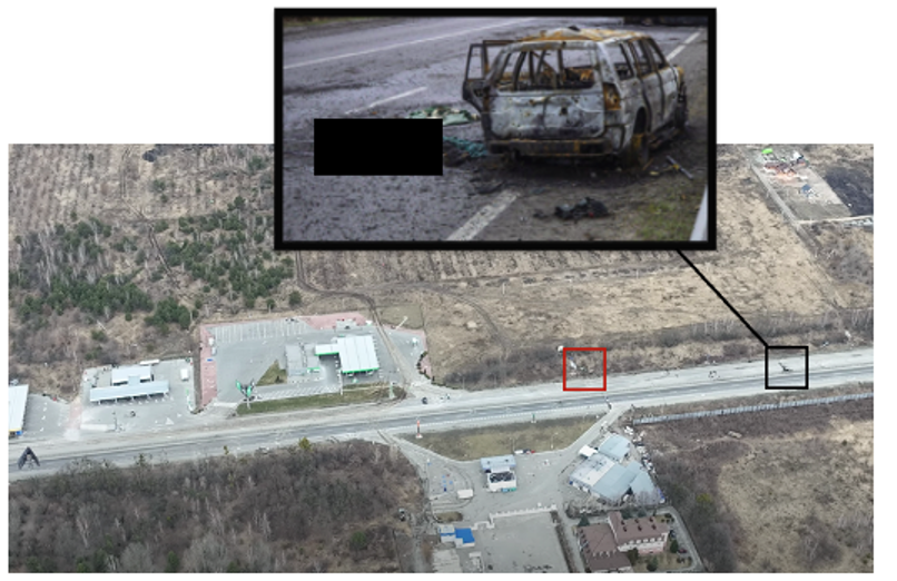
Figure 18: Red= Russian tank position, Black= Two later discovered deceased and burned corpses with Ukrainian military uniform.
Russian forces were visually confirmed to have set up a camp behind one of the gas stations where 11 people were killed as indicated within red, showing two russian vehicles and a tent.
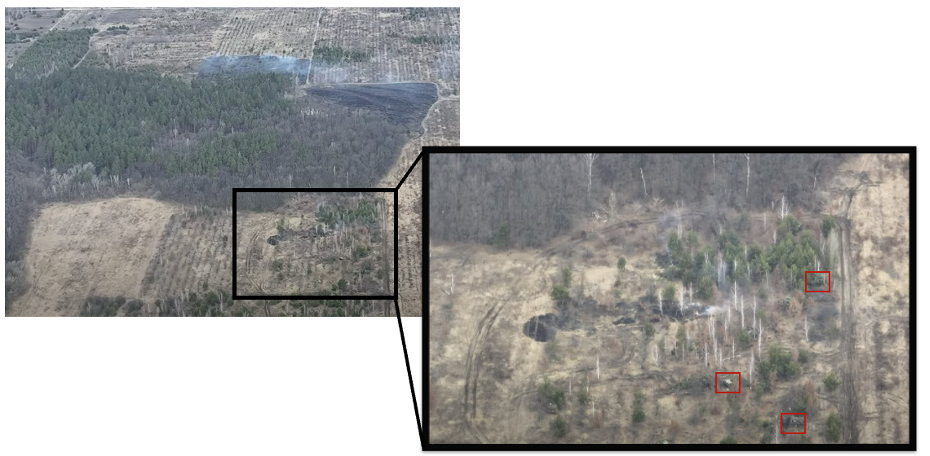
Figure 19: Russian forces present behind the gas station.
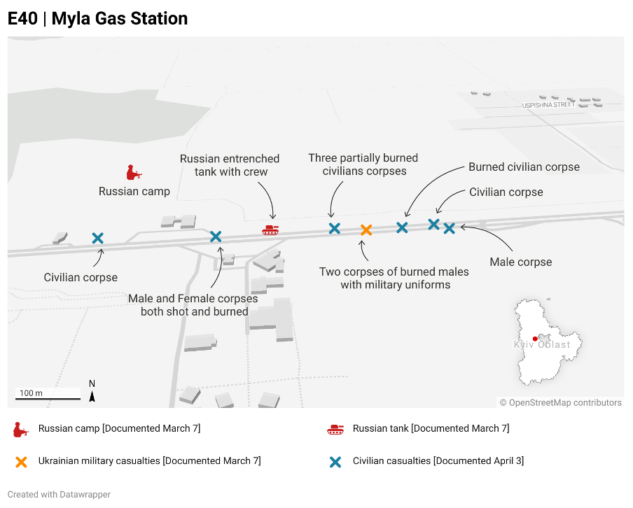
Figure 20: Overview of bodies and Russian military presence around Myla gas stations along the E40.
Along this section of the E40 highway, at least 7 civilian, Two men with military uniform and one unknown casualties are visually confirmed:
[Image 1] One deceased civilian at a gas station: 50.440190, 30.145752
[Image] 2 deceased and burned civilians: 50.440224, 30.148194
[Image 1] Two deceased females, one unknown, partially burned: 50.440436, 30.150693
[Video] 2 deceased and burned man with military uniform: 50.440367 30.151110
[Image 2] Deceased and burned civilian: 50.440446, 30.152131
[Image 3] Deceased man: 50.440435, 30.153137
[Image] Deceased civilian: 50.440540, 30.152829
Case 6 – Buzov [E40]: Two deceased men excavated from grave behind gas station, next to Russian camp
Further footage released on April 10 showing the excavation of multiple bodies behind a gas station was geolocated by the Eyes on Russia team to the gas station where Russian forces set up camp and where Russian forces were visually confirmed to be shooting at civilian vehicles.
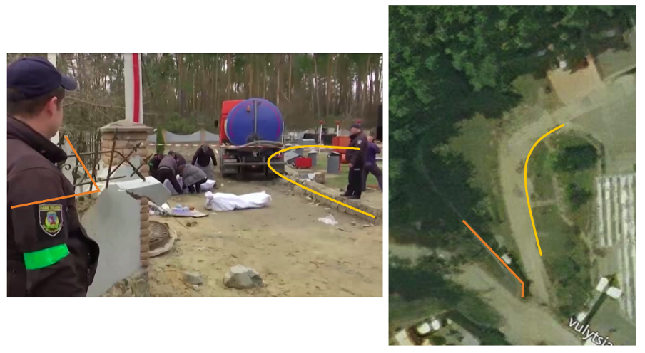
Figure 21: Geolocation of two excavated behind a gas station, next to a Russian camp.
The Eyes on Russia team was able to geolocate dashcam footage published on March 18 showing civilians coming under Russian fire after entering the E40 highway. This was only eight kilometres further west of the location of the drone footage and civilian casualties.
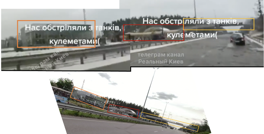
Figure 22: Geolocation of dashcam footage showing Russian forces firing at a civilian vehicle.
Russian forces were visually confirmed to be at the same highway on an off ramp as the dashcam footage showing civilian vehicles coming under fire, shown in images published on March 19. The footage is taken at the same gas station at which two bodies were excavated.
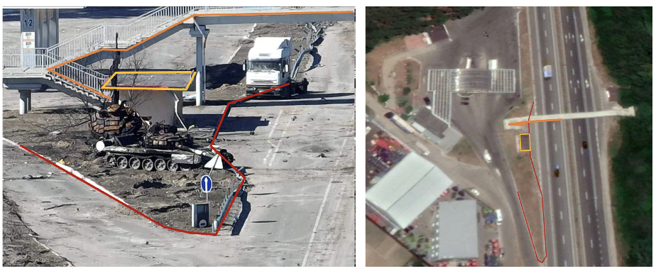
Figure 23: Geolocation of Russian forces at gas station.
On March 25, drone footage was released revealing the presence of a Russian military camp inside a forest area geolocated 900 meters east of the above mentioned incidents.
Additional drone footage shared on March 30 and April 6 showing Russian troops inside the same forest area.
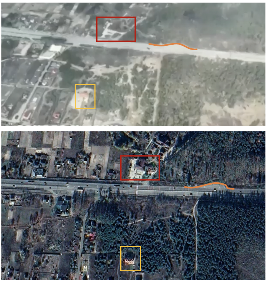
Figure 24: Geolocation of Russian forces near the gas station.
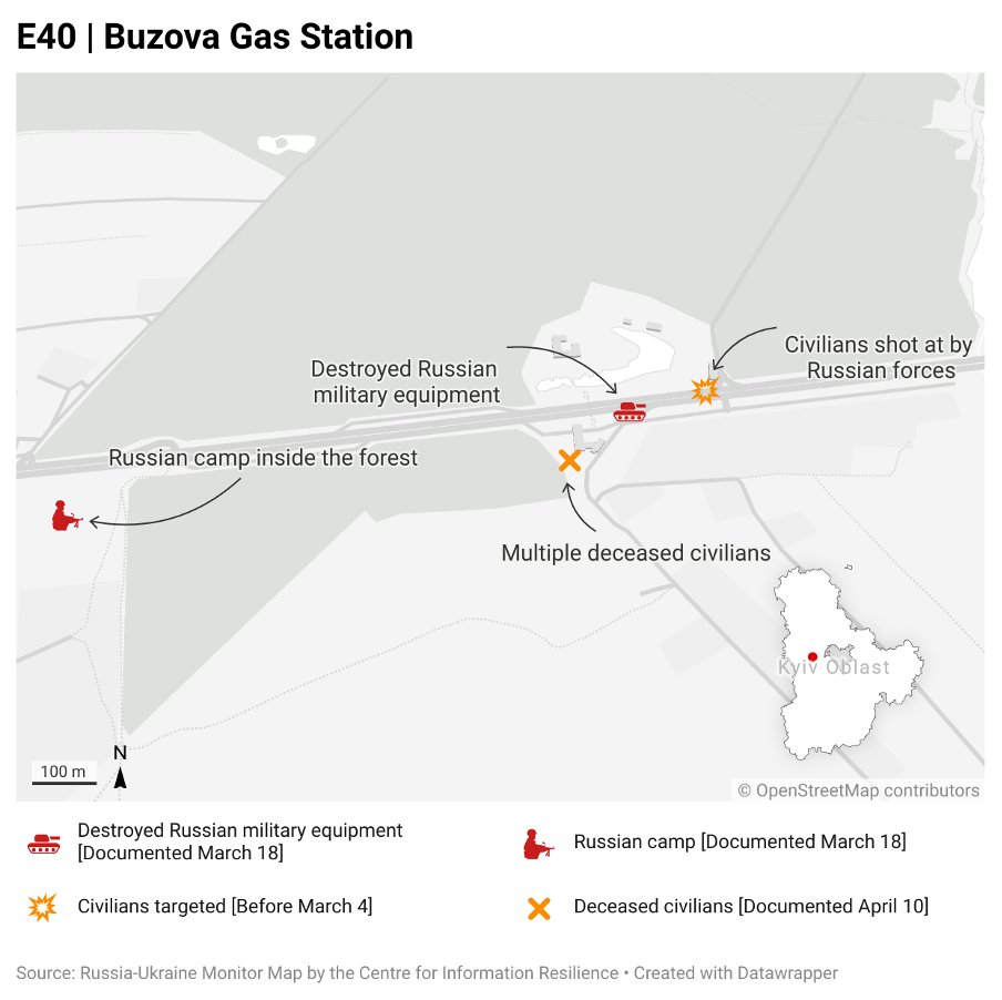
Figure 25: Local map showing documented locations of Russian troops near Buzova gas station
[Drone footage, Drone footage, Drone footage] Russian camp inside the forest: 50.428978, 30.016900
[Video] Excavation of multiple deceased civilians: 50.429781, 30.027493
[Image] Destroyed Russian military equipment: 50.430523, 30.028849
[Dashcam footage] Civilians shot at by Russian forces: 50.430830, 30.029968